About ESA
The European Space Agency (ESA) is Europe’s gateway to space. Its mission is to shape the development of Europe’s space capability and ensure that investment in space continues to deliver benefits to the citizens of Europe and the world.
Highlights


Latest


Space in Member States
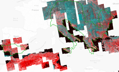
Find out more about space activities in our 23 Member States, and understand how ESA works together with their national agencies, institutions and organisations.
 Germany
 Austria
 Belgium
 Denmark
 Spain
Spain
 Estonia
 Finland
 France
 Greece
 Hungary
 Ireland
 Italy
Italy
 Luxembourg
 Norway
 The Netherlands
 Poland
 Portugal
 Czechia
 Romania
 United Kingdom
 Slovenia
 Sweden
 Switzerland
Science & Exploration
Exploring our Solar System and unlocking the secrets of the Universe
Go to topicAstronauts


Latest


Enabling & Support
Making space accessible and developing the technologies for the future
Go to topicLatest


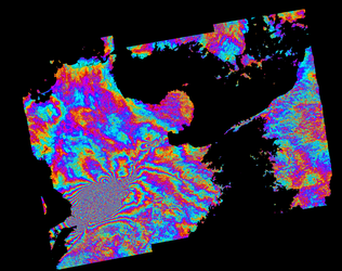
Earthquake area in Italy
This interferogram shows how the ground moved as a result of the earthquakes that struck Amatrice in Italy on 24 August 2016.
The image was generated automatically on the Geohazards Exploitation Platform and combines images captured by Sentinel-1A before and after the quakes. The Geohazards Exploitation Platform gives users direct access to large Earth-observation datasets for areas at risk of earthquakes or volcanic activity, for example. Pairs of Sentinel-1A radar images from consecutive passes over the same spot on Earth’s service are processed continuously and automatically to provide medium-resolution (200 m) images. These interferograms allow users to identify ground movement and other changes that may have occurred between satellite acquisitions. Although the service only covers Europe, this illustrates how information on major events can be made available to users. Over the next months, the browse service will be ramped up gradually to cover the global tectonic ‘mask’. This mask corresponds to regions where the shape of the ground is deforming because of tectonic activity and prioritised by the geohazards user community.