
About ESA
The European Space Agency (ESA) is Europe’s gateway to space. Its mission is to shape the development of Europe’s space capability and ensure that investment in space continues to deliver benefits to the citizens of Europe and the world.
Highlights


Latest


Space in Member States
Find out more about space activities in our 23 Member States, and understand how ESA works together with their national agencies, institutions and organisations.
 Germany
 Austria
 Belgium
 Denmark
 Spain
Spain
 Estonia
 Finland
 France
 Greece
 Hungary
 Ireland
 Italy
Italy
 Luxembourg
 Norway
 The Netherlands
 Poland
 Portugal
 Czechia
 Romania
 United Kingdom
 Slovenia
 Sweden
 Switzerland
Science & Exploration
Exploring our Solar System and unlocking the secrets of the Universe
Go to topicAstronauts


Latest


Enabling & Support
Making space accessible and developing the technologies for the future
Go to topicLatest


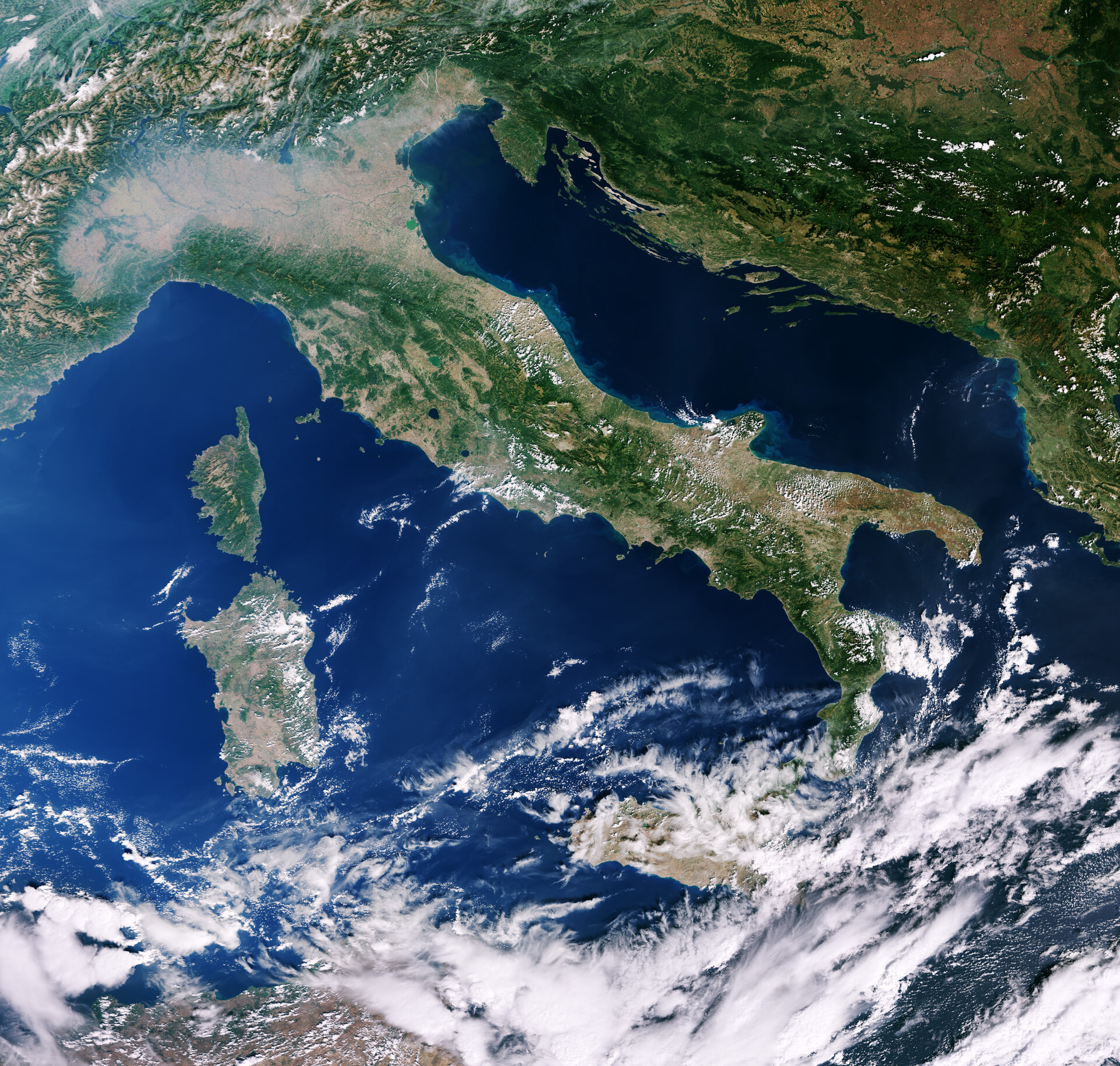
Italy and Mediterranean
The Copernicus Sentinel-3A satellite carries a suite of state-of-the art sensors that deliver a wealth of information to monitor our changing world, but this image was captured with its ocean and land camera. With a swath-width of 1270 km, this instrument delivers images that can span several countries, as we see here.
From east to west, the image features the islands of Corsica and Sardinia in the Mediterranean Sea, Italy and across the Adriatic Sea to Croatia, Bosnia and Herzegovina, Serbia, and to the western edges of Romania. To the north and partly obscured by clouds, lie Germany, Switzerland, Austria and the Alps.
South of the Alps, haze hovers over Italy’s Po Valley. Following the Po River to the east, the sediment it carries can be seen entering the Adriatic Sea. In fact, sediments line most of the eastern coast of Italy, giving it a greenish blue frame, while the western coast is mostly sediment-free.
As the colours in this image suggest, the camera can be used to monitor ocean ecosystems and vegetation on land – all of which will bring significant benefits to society through more informed decision-making.
Sentinel-3A will soon be joined in orbit by its twin Sentinel-3B, which is scheduled for liftoff from Russia on 25 April. The pairing of identical satellites provides the best coverage and data delivery for Europe’s Copernicus programme – the largest environmental monitoring programme in the world.
The image, which is also featured on the Earth from Space video programme, was captured by Sentinel-3A on 28 September 2016.

