Accept all cookies Accept only essential cookies See our Cookie Notice

About ESA
The European Space Agency (ESA) is Europe’s gateway to space. Its mission is to shape the development of Europe’s space capability and ensure that investment in space continues to deliver benefits to the citizens of Europe and the world.
Highlights
ESA - United space in Europe
This is ESA ESA facts Member States & Cooperating States Funding Director General Top management For Member State Delegations European vision European Space Policy ESA & EU Space Councils Responsibility & Sustainability Annual Report Calendar of meetings Corporate newsEstablishments & sites
ESA Headquarters ESA ESTEC ESA ESOC ESA ESRIN ESA EAC ESA ESAC Europe's Spaceport ESA ESEC ESA ECSAT Brussels Office Washington OfficeWorking with ESA
Business with ESA ESA Commercialisation Gateway Law at ESA Careers Cyber resilience at ESA IT at ESA Newsroom Partnerships Merchandising Licence Education Open Space Innovation Platform Integrity and Reporting Administrative Tribunal Health and SafetyMore about ESA
History ESA Historical Archives Exhibitions Publications Art & Culture ESA Merchandise Kids Diversity ESA Brand Centre ESA ChampionsSpace in Member States
Find out more about space activities in our 23 Member States, and understand how ESA works together with their national agencies, institutions and organisations.
Science & Exploration
Exploring our Solar System and unlocking the secrets of the Universe
Go to topicAstronauts
Missions
Juice Euclid Webb Solar Orbiter BepiColombo Gaia ExoMars Cheops Exoplanet missions More missionsActivities
International Space Station Orion service module Gateway Concordia Caves & Pangaea BenefitsLatest
Space Safety
Protecting life and infrastructure on Earth and in orbit
Go to topicAsteroids
Asteroids and Planetary Defence Asteroid danger explained Flyeye telescope: asteroid detection Hera mission: asteroid deflection Near-Earth Object Coordination CentreSpace junk
About space debris Space debris by the numbers Space Environment Report In space refuelling, refurbishing and removingSafety from space
Clean Space ecodesign Zero Debris Technologies Space for Earth Supporting Sustainable DevelopmentApplications
Using space to benefit citizens and meet future challenges on Earth
Go to topicObserving the Earth
Observing the Earth Future EO Copernicus Meteorology Space for our climate Satellite missionsCommercialisation
ESA Commercialisation Gateway Open Space Innovation Platform Business Incubation ESA Space SolutionsLatest
Enabling & Support
Making space accessible and developing the technologies for the future
Go to topicBuilding missions
Space Engineering and Technology Test centre Laboratories Concurrent Design Facility Preparing for the future Shaping the Future Discovery and Preparation Advanced Concepts TeamSpace transportation
Space Transportation Ariane Vega Space Rider Future space transportation Boost! Europe's Spaceport Launches from Europe's Spaceport from 2012Latest

First light from HyperScout imager
Thank you for liking
You have already liked this page, you can only like it once!
This first-light image from the miniature HyperScout instrument aboard ESA’s newly launched GomX-4B CubeSat, shows the southern coast of Cuba.
GomX-4B, launched with partner nanosatellite GomX-4A on 2 February, is a multi-technology demonstration mission that is testing intersatellite radio links and micro-propulsion technologies , as well as this hyperspectral imager, developed by cosine Research in the Netherlands.
Colour equals information, so the more spectral bands an Earth-observing instrument sees, the greater quantity of environmental findings can be returned to its homeworld.
“Far more compact than previous hyperspectral imagers, HyperScout can observe in 45 visible and near-infrared spectral bands,” explains ESA optics engineer Alessandro Zuccaro Marchi.
“This is a single image with a footprint of approximately 200 x 150 sq. km where each horizontal line shows the scene in a different spectral band, proving the overall functioning chain of the HyperScout works as planned – from acquisition to compression and downlink to the ground.”
Marco Esposito of cosine Research adds: “This is very much a raw image, including atmospheric and solar effects that would normally be corrected as part of the full calibration and processing chain. It has also has undergone compression and pixel ‘binning’ to fit the limited satellite power and memory resources available during commissioning. But the amount of light captured here exceeds our expectations, suggesting a very promising signal-to-noise ratio is achievable for hyperspectral applications.
“We’re very pleased with this ‘first light’ view, and follow-up images will explore HyperScout’s hyperspectral capabilities.”
HyperScout is a ‘linear variable filter’ instrument, meaning each horizontal line of pixels it observes is seen at a different wavelength from 400 to 1000 nanometres, with the onward movement of the satellite allowing the rapid build-up of a complete hyperspectral image.
The instrument will target specific regions across the globe, intended to highlight rapid changes such as flooding, fire hazards, or variations in vegetation, or land cover and use occurring between acquisitions.
-
CREDIT
ESA/cosine Research -
LICENCE
ESA Standard Licence

Hera's first images (HyperScout H)

HyperScout H placed in test chamber

Spooky Earths seen by Hera’s HyperScout

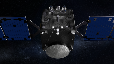
Hera's instruments on its top 'asteroid deck'


 Germany
 Austria
 Belgium
 Denmark
 Spain
Spain
 Estonia
 Finland
 France
 Greece
 Hungary
 Ireland
 Italy
Italy
 Luxembourg
 Norway
 The Netherlands
 Poland
 Portugal
 Czechia
 Romania
 United Kingdom
 Slovenia
 Sweden
 Switzerland


