About ESA
The European Space Agency (ESA) is Europe’s gateway to space. Its mission is to shape the development of Europe’s space capability and ensure that investment in space continues to deliver benefits to the citizens of Europe and the world.
Highlights


Latest


Space in Member States
Find out more about space activities in our 23 Member States, and understand how ESA works together with their national agencies, institutions and organisations.
 Germany
 Austria
 Belgium
 Denmark
 Spain
Spain
 Estonia
 Finland
 France
 Greece
 Hungary
 Ireland
 Italy
Italy
 Luxembourg
 Norway
 The Netherlands
 Poland
 Portugal
 Czechia
 Romania
 United Kingdom
 Slovenia
 Sweden
 Switzerland
Science & Exploration
Exploring our Solar System and unlocking the secrets of the Universe
Go to topicAstronauts


Latest


Enabling & Support
Making space accessible and developing the technologies for the future
Go to topicLatest


Sicily hotspot
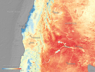
Launched on 25 April 2018, Sentinel-3B has already delivered some impressive first images from its ocean and land colour instrument, from its altimeter and from the optical channels of its radiometer. With the radiometer’s thermal-infrared channels now turned on, the satellite completes its set of firsts with an image that depicts thermal signatures over southern Italy, the Mediterranean Sea and Sicily – with the hotspot of Mount Etna clearly visible. This image shows the ‘brightness temperature’, which corresponds to radiation emitted from the surface. Further processing is needed to turn this into an actual temperature map. The land surface is shown in red–orange colours, corresponding to a brightness temperature range of 296–320K. The blue colours over the ocean correspond to a range of 290–295K. The dark blue–black areas correspond to clouds, which are opaque to thermal-infrared radiation and so prevent a view of the ocean or land surface.
Mount Etna, Europe’s largest and most active volcano, appears much hotter than the surrounding land. In a state of almost continuous unrest, the volcano is currently classified as having ‘minor activity’.
Over the oceans, the Sentinel-3 radiometer is important for providing sea-surface temperature measurements for oceanographic and weather forecasting centres. Over land, the instrument can be used, in particular, to monitor urban heat islands and wildfires.
Sentinel-3B joins its identical twin, Sentinel-3A, in orbit. This pairing of satellites increases coverage and data delivery for the European Union’s Copernicus environment programme.