About ESA
The European Space Agency (ESA) is Europe’s gateway to space. Its mission is to shape the development of Europe’s space capability and ensure that investment in space continues to deliver benefits to the citizens of Europe and the world.
Highlights


Latest


Space in Member States
Find out more about space activities in our 23 Member States, and understand how ESA works together with their national agencies, institutions and organisations.
 Germany
 Austria
 Belgium
 Denmark
 Spain
Spain
 Estonia
 Finland
 France
 Greece
 Hungary
 Ireland
 Italy
Italy
 Luxembourg
 Norway
 The Netherlands
 Poland
 Portugal
 Czechia
 Romania
 United Kingdom
 Slovenia
 Sweden
 Switzerland
Science & Exploration
Exploring our Solar System and unlocking the secrets of the Universe
Go to topicAstronauts


Latest


Enabling & Support
Making space accessible and developing the technologies for the future
Go to topicLatest


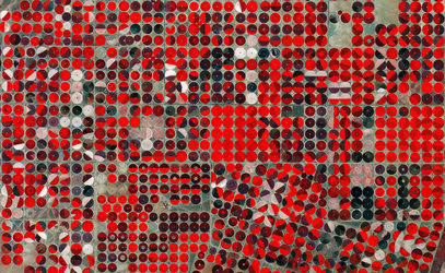
Egyptian crop circles
This week, ESA is focusing on its core Basic Activities, which, for Earth observation, include preserving precious data. Long-time series of datasets are needed to determine changes in our planet’s climate so it is vital that satellite data and other Earth science data are preserved for future generations and are still accessible and usable after many years.
This example includes a series of satellite images going back to 1998.
Egypt is over 95% desert, making a very small proportion of its land suitable for agriculture. As the demand for food grows, the need for agricultural development in desert areas has intensified.
This set of images shows an important land reclamation project in East Oweinat, in the Western Desert of Egypt.
Consisting of a long-time series of over 150 images captured by the US Landsat and the Copernicus Sentinel-2 missions, this comparison highlights how this agricultural project has developed between January 1998 and March 2019.
The circular shapes in the images, each approximately 800 metres wide, indicate the irrigation method used here, with water being supplied by a set of sprinklers rotating around a central pivot. Fossil water, stored underground for thousands of years, comes from the Nubian Sandstone Aquifer, the largest known fossil aquifer discovered.
The water in the East Oweinat area is low in salt content, making it ideal for cultivation purposes. Crops such as wheat, potatoes and barley are grown here, and are exported through the Sharq El Owainat airport, visible in the right side of the image.
Another interesting feature in this time series is the drifting sand dunes visible mainly in the upper left corner, which is a phenomena common in sandy deserts with constant winds.
Changes over the last 21 years are clearly visible when more fields develop, but the data also show other subtle changes within the fields themselves. This data can be used to monitor changes in land-cover over time. Long-term preservation of the satellite data from different missions ensures that changes to the land can be monitored by analysing data from the archives.
These images are also featured on the Earth from Space video programme.