About ESA
The European Space Agency (ESA) is Europe’s gateway to space. Its mission is to shape the development of Europe’s space capability and ensure that investment in space continues to deliver benefits to the citizens of Europe and the world.
Highlights


Latest


Space in Member States
Find out more about space activities in our 23 Member States, and understand how ESA works together with their national agencies, institutions and organisations.
 Germany
 Austria
 Belgium
 Denmark
 Spain
Spain
 Estonia
 Finland
 France
 Greece
 Hungary
 Ireland
 Italy
Italy
 Luxembourg
 Norway
 The Netherlands
 Poland
 Portugal
 Czechia
 Romania
 United Kingdom
 Slovenia
 Sweden
 Switzerland
Science & Exploration
Exploring our Solar System and unlocking the secrets of the Universe
Go to topicAstronauts


Latest


Enabling & Support
Making space accessible and developing the technologies for the future
Go to topicLatest


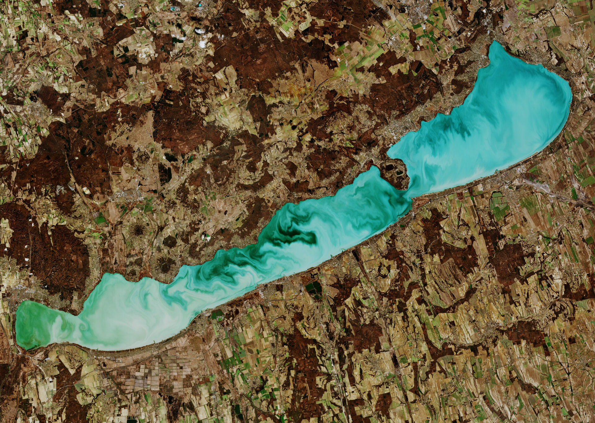
Lake Balaton, Hungary
The Copernicus Sentinel-2 mission takes us over Lake Balaton in western Hungary. With a surface area of around 600 sq km and a length of around 78 km, this freshwater lake is the largest in central Europe.
The lake is mainly fed by the Zala River at its western end. The lakewater flows out near the eastern end via an artificial channel called the Sió, which eventually feeds into the Danube River.
Originally five separate water bodies, the barriers between have been eroded away to create the lake it is today. Remnants of the dividing ridges can be seen in Balaton’s shape – with the Tihany Peninsula on the northern shore narrowing the width of the lake to approximately 1.5 km.
Lake Balaton’s striking emerald-green colour in this image is most likely due to its shallow waters and chemical composition. It is heavy in carbonates and sulphates, and there are also around 2000 species of algae that grow in its waters.
The lake supports a large population of plant and animal species. During migration and wintering sessions, the site is an important staging area for thousands of ducks and geese.
Owing to its pleasant climate and fresh water, the Lake Balaton area is a popular tourist destination. The mountainous northern region is known for its wine, while popular tourist towns lie on the flatter southern shore.
Sentinel-2 is a two-satellite mission to supply the coverage and data delivery needed for Europe’s Copernicus programme. The mission’s frequent revisits over the same area and high spatial resolution allow changes in inland water bodies to be closely monitored.
This image, captured on 27 February 2019, is also featured on the Earth from Space video programme.