About ESA
The European Space Agency (ESA) is Europe’s gateway to space. Its mission is to shape the development of Europe’s space capability and ensure that investment in space continues to deliver benefits to the citizens of Europe and the world.
Highlights


Latest


Space in Member States
Find out more about space activities in our 23 Member States, and understand how ESA works together with their national agencies, institutions and organisations.
 Germany
 Austria
 Belgium
 Denmark
 Spain
Spain
 Estonia
 Finland
 France
 Greece
 Hungary
 Ireland
 Italy
Italy
 Luxembourg
 Norway
 The Netherlands
 Poland
 Portugal
 Czechia
 Romania
 United Kingdom
 Slovenia
 Sweden
 Switzerland
Science & Exploration
Exploring our Solar System and unlocking the secrets of the Universe
Go to topicAstronauts


Latest


Enabling & Support
Making space accessible and developing the technologies for the future
Go to topicLatest


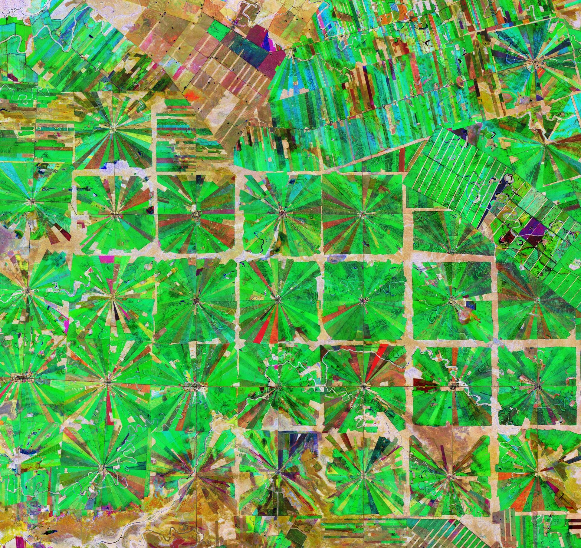
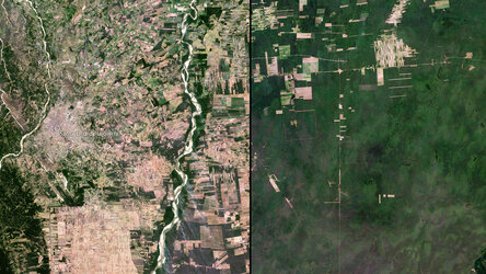
Deforestation in Bolivia
This Copernicus Sentinel-2 image features an area in the Santa Cruz Department of Bolivia, where part of the tropical dry forest has been cleared for agricultural use.
Since the 1980s, the area has been rapidly deforested owing to a large agricultural development effort where people from the Andean high plains (the Altiplano region) have been relocated to the lowlands of Bolivia.
The relatively flat lowlands and abundant rainfall make this region suitable for farming. In fact, the local climate allows farmers to benefit from two growing seasons. The region has been transformed from dense forest into a patterned expanse of agricultural land. This deforestation method, common in this part of Bolivia, is characterised by the radial patterns that can be seen clearly in the image.
Each patterned field is approximately 20 sq km and each side is around 2.5 km long.
Small settlements can be seen in the centre of each individual field in the image, which typically contain a church, a school and a soccer field. These communities are joined by a road network depicted by the straight lines that bisect the radial fields and connect the adjacent areas.
Meandering streams and rivers can be seen flowing through the fields. The long, thin strips of land in the top right of the image are most likely cultivated soybean fields.
Rainforests worldwide are being destroyed at an alarming rate. This is of great concern as they play an important role in global climate, and are home to a wide variety of plants and animals.
Because of their unique perspective from space, Earth observation satellites are instrumental in providing comprehensive information on the full extent and rate of deforestation, which is particularly useful for monitoring remote areas.
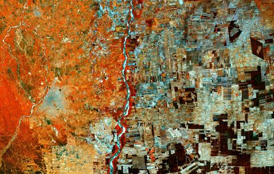
This composite image was created by combing three separate ‘Normalised Difference Vegetation Index’ images from the Copernicus Sentinel-2 mission. The first image, from 8 April 2019, is visible in red; the second from 22 June 2019, can be seen in green; and the third from 5 September 2019 can be seen in blue. The Normalised Difference Vegetation Index is widely used in remote sensing as it gives scientists an accurate measure of healthy and status of plant growth.
This image is also featured on the Earth from Space video programme.