About ESA
The European Space Agency (ESA) is Europe’s gateway to space. Its mission is to shape the development of Europe’s space capability and ensure that investment in space continues to deliver benefits to the citizens of Europe and the world.
Highlights


Latest


Space in Member States
Find out more about space activities in our 23 Member States, and understand how ESA works together with their national agencies, institutions and organisations.
 Germany
 Austria
 Belgium
 Denmark
 Spain
Spain
 Estonia
 Finland
 France
 Greece
 Hungary
 Ireland
 Italy
Italy
 Luxembourg
 Norway
 The Netherlands
 Poland
 Portugal
 Czechia
 Romania
 United Kingdom
 Slovenia
 Sweden
 Switzerland
Science & Exploration
Exploring our Solar System and unlocking the secrets of the Universe
Go to topicAstronauts


Latest


Enabling & Support
Making space accessible and developing the technologies for the future
Go to topicLatest


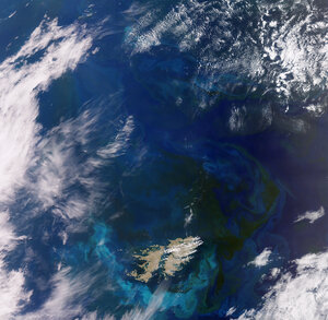
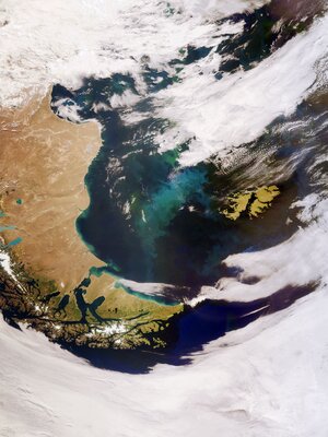
Falkland Islands
The Falkland Islands are featured in this radar image captured by the Copernicus Sentinel-1 mission.
The Falkland Islands lie in the South Atlantic Ocean, around 500 km northeast of the southern tip of South America. The Falklands comprise two main islands, West Falkland and East Falkland, as well as hundreds of other smaller islands and islets, which form a total land area approximately five times the size of Luxembourg. The two main islands are separated by the Falkland Sound, a channel that averages around 20 km in width.
This multi-temporal image combines two radar acquisitions from the Copernicus Sentinel-1 mission taken one month apart to show changes over time. The first image was captured on 29 December 2019, while the second was taken on 22 January 2020. Here, the main changes between acquisitions occurred in the open ocean, with the bright red colours showing wavy waters in December 2019.
The Copernicus Sentinel-1 mission provides a continuous sampling of the seas, offering information on wind and waves. This is useful for understanding interactions between waves and currents and to improve efficiency for shipping and wave-energy applications, potentially producing economic benefits.
The landscape of the Falkland Islands comprises mountain ranges, flat plains, rugged coastline and cliffs. Hills run east-west across the northern parts of the two main islands, with the highest point being Mount Usborne on East Falkland (around 700 m). Two inlets, Berkeley Sound and Port William, visible in the far right of the image, run far into the land and provide anchorage for shipping. The majority of the population of the islands live in Stanley, on East Falkland.
The islands are covered with grasslands, but not trees, which are widely used as pastureland for sheep and cattle. The islands are also an important habitat and breeding grounds for birds, penguins and seals.
This image is also featured on the Earth from Space video programme.