Accept all cookies Accept only essential cookies See our Cookie Notice

About ESA
The European Space Agency (ESA) is Europe’s gateway to space. Its mission is to shape the development of Europe’s space capability and ensure that investment in space continues to deliver benefits to the citizens of Europe and the world.
Highlights
ESA - United space in Europe
This is ESA ESA facts Member States & Cooperating States Funding Director General Top management For Member State Delegations European vision European Space Policy ESA & EU Space Councils Responsibility & Sustainability Annual Report Calendar of meetings Corporate newsEstablishments & sites
ESA Headquarters ESA ESTEC ESA ESOC ESA ESRIN ESA EAC ESA ESAC Europe's Spaceport ESA ESEC ESA ECSAT Brussels Office Washington OfficeWorking with ESA
Business with ESA ESA Commercialisation Gateway Law at ESA Careers Cyber resilience at ESA IT at ESA Newsroom Partnerships Merchandising Licence Education Open Space Innovation Platform Integrity and Reporting Administrative Tribunal Health and SafetyMore about ESA
History ESA Historical Archives Exhibitions Publications Art & Culture ESA Merchandise Kids Diversity ESA Brand Centre ESA ChampionsLatest
Space in Member States
Find out more about space activities in our 23 Member States, and understand how ESA works together with their national agencies, institutions and organisations.
Science & Exploration
Exploring our Solar System and unlocking the secrets of the Universe
Go to topicAstronauts
Missions
Juice Euclid Webb Solar Orbiter BepiColombo Gaia ExoMars Cheops Exoplanet missions More missionsActivities
International Space Station Orion service module Gateway Concordia Caves & Pangaea BenefitsLatest
Space Safety
Protecting life and infrastructure on Earth and in orbit
Go to topicAsteroids
Asteroids and Planetary Defence Asteroid danger explained Flyeye telescope: asteroid detection Hera mission: asteroid deflection Near-Earth Object Coordination CentreSpace junk
About space debris Space debris by the numbers Space Environment Report In space refuelling, refurbishing and removingSafety from space
Clean Space ecodesign Zero Debris Technologies Space for Earth Supporting Sustainable DevelopmentLatest
Applications
Using space to benefit citizens and meet future challenges on Earth
Go to topicObserving the Earth
Observing the Earth Future EO Copernicus Meteorology Space for our climate Satellite missionsCommercialisation
ESA Commercialisation Gateway Open Space Innovation Platform Business Incubation ESA Space SolutionsLatest
Enabling & Support
Making space accessible and developing the technologies for the future
Go to topicBuilding missions
Space Engineering and Technology Test centre Laboratories Concurrent Design Facility Preparing for the future Shaping the Future Discovery and Preparation Advanced Concepts TeamSpace transportation
Space Transportation Ariane Vega Space Rider Future space transportation Boost! Europe's Spaceport Launches from Europe's Spaceport from 2012Latest

Utah's Great Salt Lake
Thank you for liking
You have already liked this page, you can only like it once!
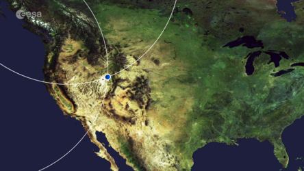
Utah’s Great Salt Lake and its surroundings are featured in this false-colour image captured by the Copernicus Sentinel-2 mission.
The Great Salt Lake is the largest salt water lake in the western hemisphere, and one of the most saline inland bodies of water in the world. The Great Salt Lake is the largest of the lake remnants of prehistoric freshwater Lake Bonneville, that once covered much of western Utah.
The lake is fed by the Bear, Weber and Jordan rivers which, together, deposit around 1 million tonnes of minerals in the lake each year. As the lake is endorheic, meaning without an outlet, the water evaporates which leads to a very high salt concentration. It greatly fluctuates in size, depending on the rates of evaporation and the flow of the rivers that feed it.
The distinct colour differences in the lake are caused by the Lucin Cutoff, an east-west causeway built to create a shorter route. The railroad line is visible as a sharp line cutting across the top part of the lake. This acts as a dam, preventing the waters to mix, leading to the north basin having a much higher salinity than the southern, freshwater side of the lake.
As the lake’s main tributaries enter from the south, the water level of the southern section is slightly higher than that of the northern part. Several small islands, the largest of which are Antelope and Fremont, lie in the southern part of the lake.
The lake’s varying shoreline consists of beaches, marshes and mudflats. The bright, turquoise colours visible on both sides of the lake are evaporation ponds, from which various salts are collected in commercial operations. Although it is commonly referred to as America’s Dead Sea, the lake is nevertheless an important habitat for millions of native and migratory birds. It is also home to several types of algae, brine shrimp and brine flies.
The lake’s basin is defined by the foothills of the snow-capped Wasatch Range, to the east, and by the Great Salt Lake Desert, a remnant of the bed of Lake Bonneville, to the west. This part of the desert is known as the Bonneville Salt Flats and is used as an automobile raceway, as the flat and smooth salt beds make the area ideally suited for speed trials. Utah’s capital, Salt Lake City, is visible in the bottom right of the image.
This image was processed in a way that included the near-infrared channel, which makes vegetation appear in red, while rocks and bare soil appear in brown. Copernicus Sentinel-2 is a two-satellite mission. Each satellite carries a high-resolution camera that images Earth’s surface in 13 spectral bands. The mission’s frequent revisits over the same area and high spatial resolution allow changes in inland water bodies to be closely monitored.
This image, which was captured on 17 March 2019, is also featured on the Earth from Space video programme.
-
CREDIT
contains modified Copernicus Sentinel data (2019), processed by ESA -
LICENCE
CC BY-SA 3.0 IGO or ESA Standard Licence
(content can be used under either licence)

Earth from Space: Utah’s Great Salt Lake

Puzzle of Utah

Salt Lake, Utah

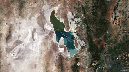
Great Salt Lake in July 2022


 Germany
 Austria
 Belgium
 Denmark
 Spain
Spain
 Estonia
 Finland
 France
 Greece
 Hungary
 Ireland
 Italy
Italy
 Luxembourg
 Norway
 The Netherlands
 Poland
 Portugal
 Czechia
 Romania
 United Kingdom
 Slovenia
 Sweden
 Switzerland


