About ESA
The European Space Agency (ESA) is Europe’s gateway to space. Its mission is to shape the development of Europe’s space capability and ensure that investment in space continues to deliver benefits to the citizens of Europe and the world.
Highlights


Latest


Space in Member States
Find out more about space activities in our 23 Member States, and understand how ESA works together with their national agencies, institutions and organisations.
 Germany
 Austria
 Belgium
 Denmark
 Spain
Spain
 Estonia
 Finland
 France
 Greece
 Hungary
 Ireland
 Italy
Italy
 Luxembourg
 Norway
 The Netherlands
 Poland
 Portugal
 Czechia
 Romania
 United Kingdom
 Slovenia
 Sweden
 Switzerland
Science & Exploration
Exploring our Solar System and unlocking the secrets of the Universe
Go to topicAstronauts


Latest


Enabling & Support
Making space accessible and developing the technologies for the future
Go to topicLatest


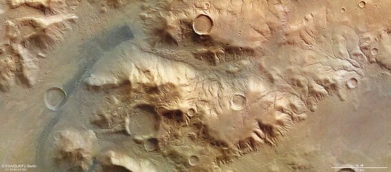
Stereoscopic view of the Nereidum Mountain Range on Mars
A stereoscopic image of a region in the Nereidum Mountain Range in the southern hemisphere of Mars generated from data captured by the High Resolution Stereo Camera (HRSC) on ESA's Mars Express orbiter in 2015.
The image, derived from data acquired by the nadir channel and the stereo channels of the HRSC camera provides a three-dimensional experience when viewed using red-green or red-blue glasses.
Evidence of geological processes that have shaped the region north of the large Argyre impact basin can be seen in the image.
Branch-like structures of valleys were carved into the slopes either by the melting snow and ice or runoff from rain in the early period of Mars’ evolution when the planet had abundant water resources.
Inside the craters in the image, one can see deposits, in some cases concentric, probably created by the sublimation of ice that used to cover the region in the past. Scientists believe water ice might still be present in the region deep under the surface.
Mass wasting deposits clearly visible in the canyons captured in this image are also a result of glacial processes that had taken place in the area in the past.
The dark streak on the left-hand side of the image represents dune fields created by the effects of wind as it transports sand grains over large distances on the surface of Mars. On the north-facing slope of the ridge between the northern part of the dune field and the large filled crater towards the south, one can clearly see recently created alcoves and gullies. These structures are often linked to the melting of ground ice and could also point to still existing water ice deposits in the subsurface.