About ESA
The European Space Agency (ESA) is Europe’s gateway to space. Its mission is to shape the development of Europe’s space capability and ensure that investment in space continues to deliver benefits to the citizens of Europe and the world.
Highlights


Latest


Space in Member States
Find out more about space activities in our 23 Member States, and understand how ESA works together with their national agencies, institutions and organisations.
 Germany
 Austria
 Belgium
 Denmark
 Spain
Spain
 Estonia
 Finland
 France
 Greece
 Hungary
 Ireland
 Italy
Italy
 Luxembourg
 Norway
 The Netherlands
 Poland
 Portugal
 Czechia
 Romania
 United Kingdom
 Slovenia
 Sweden
 Switzerland
Science & Exploration
Exploring our Solar System and unlocking the secrets of the Universe
Go to topicAstronauts


Latest


Enabling & Support
Making space accessible and developing the technologies for the future
Go to topicLatest


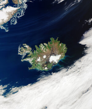
Vatnajökull, Iceland
The Copernicus Sentinel-2 mission takes us over the Vatnajökull ice cap, in southeast Iceland, in this summery image captured on 6 July 2019.
Zoom in to see this image at its full 10 m resolution.
Covering an area of around 8400 sq km, which is three times the size of Luxembourg, Vatnajökull is not only classified as the biggest glacier in Iceland, but the biggest in Europe. With an average ice thickness of around 900 m, the ice cap has about 30 outlet glaciers – many of which are retreating owing to warming temperatures.
The most prominent outlet glaciers of Vatnajökull include Dyngjujökull in the north, Breiðamerkurjökull, and Skeiðarárjökull to the south. Vatnajökull conceals some of the most active volcanoes in the country, of which Bárðarbunga is the largest and Grímsvötn the most active. Periodic eruptions of these volcanoes melt the surrounding ice and create large pockets of water, which can often burst the weakened ice causing glacial floods, or ‘jökulhlaup’ in Icelandic.
During these jökulhlaups, the glacier’s meltwater carries sediments and sands composed of ash to the coast. These outwash plains are called ‘sandurs’ and are commonly found in Iceland. Skeiðarársandur, the large area of black sand, visible south of the Skeiðarárjökull outlet glacier, covers an area of around 1300 sq km and was formed as the glacial rivers in the area washed ash and ice towards the sea.
In the bottom-right of the image, on the southern side of Vatnajökull, the Jökulsárlón glacial lake, dotted with icebergs, is visible. Jökulsárlón began to form when the Breiðamerkurjökull glacier began retreating from the Atlantic Ocean owing to rising temperatures.
The lake has grown considerably over time because of the melting of the glacier. It now covers an area of around 18 sq km, and with a maximum depth of around 250 m, it is considered Iceland’s deepest lake. The lake connects with the ocean and is, therefore, composed of both seawater and freshwater – causing its unique colour.
Copernicus Sentinel-2 is a two-satellite mission. Each satellite carries a high-resolution camera that images Earth’s surface in 13 spectral bands. Together they cover all Earth’s land surfaces, large islands, inland and coastal waters every five days at the equator.
This image is also featured on the Earth from Space video programme.