About ESA
The European Space Agency (ESA) is Europe’s gateway to space. Its mission is to shape the development of Europe’s space capability and ensure that investment in space continues to deliver benefits to the citizens of Europe and the world.
Highlights


Latest


Space in Member States
Find out more about space activities in our 23 Member States, and understand how ESA works together with their national agencies, institutions and organisations.
 Germany
 Austria
 Belgium
 Denmark
 Spain
Spain
 Estonia
 Finland
 France
 Greece
 Hungary
 Ireland
 Italy
Italy
 Luxembourg
 Norway
 The Netherlands
 Poland
 Portugal
 Czechia
 Romania
 United Kingdom
 Slovenia
 Sweden
 Switzerland
Science & Exploration
Exploring our Solar System and unlocking the secrets of the Universe
Go to topicAstronauts


Latest


Enabling & Support
Making space accessible and developing the technologies for the future
Go to topicLatest


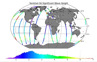
Wave height from space
As well as mapping the height of the sea surface, data from the altimeter is useful for measuring waves. Significant wave height – trough to crest of the tallest third of waves – together with wind speed over the ocean are known collectively as ‘sea state’. In the coastal zone, radar altimetry data is particularly useful for understanding storm surges, as it can be used to determine the ‘total water level envelope’, which includes the mean rise in water levels as well as the waves riding on top. Waves can ‘over-top’ coastal defences and cause catastrophic flooding, sediment transport, damage to infrastructure and loss of life.