About ESA
The European Space Agency (ESA) is Europe’s gateway to space. Its mission is to shape the development of Europe’s space capability and ensure that investment in space continues to deliver benefits to the citizens of Europe and the world.
Highlights


Latest


Space in Member States
Find out more about space activities in our 23 Member States, and understand how ESA works together with their national agencies, institutions and organisations.
 Germany
 Austria
 Belgium
 Denmark
 Spain
Spain
 Estonia
 Finland
 France
 Greece
 Hungary
 Ireland
 Italy
Italy
 Luxembourg
 Norway
 The Netherlands
 Poland
 Portugal
 Czechia
 Romania
 United Kingdom
 Slovenia
 Sweden
 Switzerland
Science & Exploration
Exploring our Solar System and unlocking the secrets of the Universe
Go to topicAstronauts


Latest


Enabling & Support
Making space accessible and developing the technologies for the future
Go to topicLatest


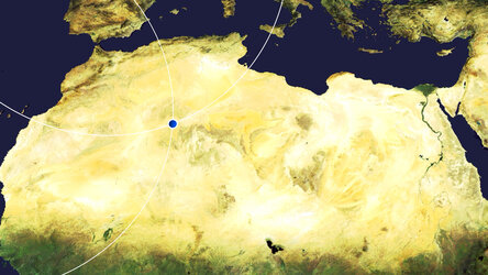
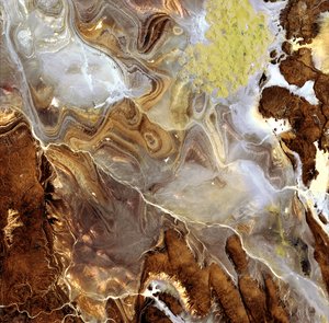
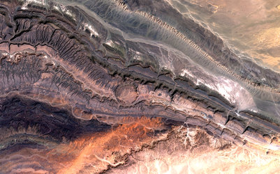
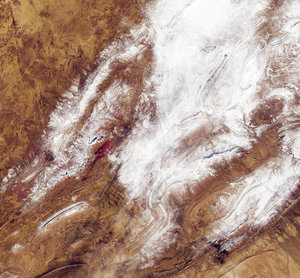
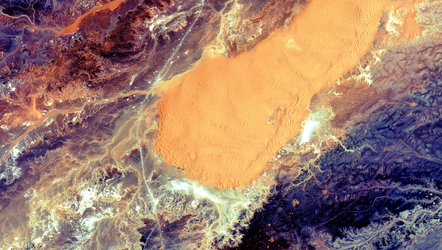
Tanezrouft Basin
The Copernicus Sentinel-2 mission takes us over the Tanezrouft Basin – one of the most desolate parts of the Sahara Desert.
Zoom in to see this image at its full 10 m resolution or click on the circles to learn more about the features in this image.
Tanezrouft is a region of the Sahara lying in southern Algeria and northern Mali. The hyperarid area is known for its soaring temperatures and scarce access to water and vegetation, a reason why it’s often referred to as the ‘Land of Terror’. There are no permanent residents that live here, only occasional Tuareg nomads.
The barren plain extends to the west of the Hoggar mountains and southeast of the sandy Erg Chech. The terrain shows evidence of water erosion that occurred many years ago, when the Sahara Desert’s climate was much wetter, as well as wind erosion caused by frequent sandstorms – exposing ancient folds in the Paleozoic rocks.
The region is characterised by dark sandstone hills, steep canyon walls, salt flats (visible in white in the image), stone plateaus and seas of multi-storey sand dunes known as ‘ergs’. Concentric rings of exposed sandstone strata create a stunning pattern predominantly visible in the left of the image.
White lines in the right of the image are roads that lead to In Salah – the capital of the In Salah Province and In Salah District. Just above the centre-left of the image, an airstrip can be seen. An interesting, grid-like pattern can be seen in the bottom of the image and mostly consists of human-made clearings and roads.
This image, also featured on the Earth from Space video programme, was captured on 12 January 2020 by the Copernicus Sentinel-2 mission – a two-satellite mission to supply the coverage and data delivery needed for Europe’s Copernicus programme.