About ESA
The European Space Agency (ESA) is Europe’s gateway to space. Its mission is to shape the development of Europe’s space capability and ensure that investment in space continues to deliver benefits to the citizens of Europe and the world.
Highlights


Latest


Space in Member States
Find out more about space activities in our 23 Member States, and understand how ESA works together with their national agencies, institutions and organisations.
 Germany
 Austria
 Belgium
 Denmark
 Spain
Spain
 Estonia
 Finland
 France
 Greece
 Hungary
 Ireland
 Italy
Italy
 Luxembourg
 Norway
 The Netherlands
 Poland
 Portugal
 Czechia
 Romania
 United Kingdom
 Slovenia
 Sweden
 Switzerland
Science & Exploration
Exploring our Solar System and unlocking the secrets of the Universe
Go to topicAstronauts


Latest


Enabling & Support
Making space accessible and developing the technologies for the future
Go to topicLatest


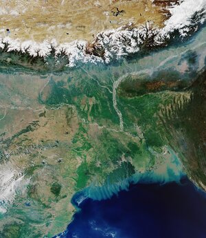
Safe drinking water for West Bengal
With some groundwater in India being contaminated with arsenic, fluoride or salt, around 27 million people are at risk of arsenic or fluoride poisoning. This can cause a range of health issues, including cancer and bone diseases, and the issue is particularly serious in the state of West Bengal.
The ADB is working with the Indian government to provide safe and sustainable drinking water to 1.65 million people in West Bengal. The Bank has explored several ways to do this; one shortlisted solution falls under the Nature-Based Solutions approach, with the aim to improve the storage of floodwater using inactive river channels along the Rupnarayan River. Some channels carry water only during the monsoon season, so during the dry season they could provide a suitable water storage solution.
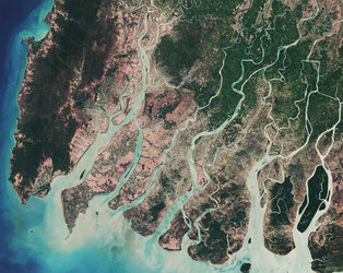
However, the ADB and its partners have no comprehensive overview of the availability of potential water storage sites in the target area. The EO Clinic recently stepped in to provide such an inventory of suitable sites.
The inventory is being built by ESA EO Clinic service providers Everis (Spain), IHCantabria (Spain) and i-Sea (France) by combining maps of surface water bodies and their dynamics – including the seasonal changes in their extent – with the latest information on land use and land cover for the surroundings of the identified seasonal water areas.
This image shows variations in the extent of the course of the Rupnarayan River in a section of West Bengal, as seen in Copernicus Sentinel-1 Synthetic Aperture Radar acquisitions.