
About ESA
The European Space Agency (ESA) is Europe’s gateway to space. Its mission is to shape the development of Europe’s space capability and ensure that investment in space continues to deliver benefits to the citizens of Europe and the world.
Highlights


Latest


Space in Member States
Find out more about space activities in our 23 Member States, and understand how ESA works together with their national agencies, institutions and organisations.
 Germany
 Austria
 Belgium
 Denmark
 Spain
Spain
 Estonia
 Finland
 France
 Greece
 Hungary
 Ireland
 Italy
Italy
 Luxembourg
 Norway
 The Netherlands
 Poland
 Portugal
 Czechia
 Romania
 United Kingdom
 Slovenia
 Sweden
 Switzerland
Science & Exploration
Exploring our Solar System and unlocking the secrets of the Universe
Go to topicAstronauts


Latest


Enabling & Support
Making space accessible and developing the technologies for the future
Go to topicLatest


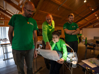
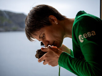
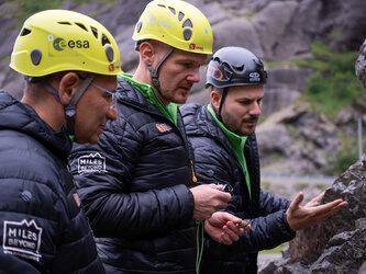
Moon rock class in session
School is also back in session for ESA astronaut Andrea Mogensen (right) and NASA astronaut Kathleen Rubins. Together with European Astronaut Centre engineer Robin Eccleston (far left), the trio are taking part in this year’s Pangaea field training campaign to become better field scientists.
With all eyes set on the Moon, the three-week campaign has increasingly focussed on lunar geology. Now in its fourth edition, the course kicked off this week with background lessons by top planetary scientists on identifying rock samples of interest for exploration.
In this image Andreas and his fellow students use a microscope to analyse samples.
Later, the class went on a field trip to the Bletterbach canyon in the Italian Dolomites. The eight-km long and 400-m deep gorge contains around 10 billion tonnes of rock transported to the valley since the end of the glacial age, around 18 000 years ago.
The gorge is the result of sedimentary processes quite similar to those found on Mars and is an ideal site to put classroom knowledge into practice.
In later sessions, the trainees will also visit the Ries Crater in Germany and the volcanic landscapes of Lanzarote, Spain, to unravel not only lunar but also martian features on Earth. They will use more sophisticated tools that will allow them to explore their geography from the microscopic to the macroscopic level.
The participants will wear a virtual reality headset to immerse themselves in a real martian landscape. Together with images and dozens of 3D maps, the trainees will see a combination of ground truth information and satellite images with the PLANetary MAPping project (PLANMAP) running behind the scenes.
Follow Pangaea on social media for live updates and on the blog for more in depth articles.
ESA astronaut Samantha Cristoforetti during geology lesson
ESA astronaut Samantha Cristoforetti analyses rock sample
ESA astronaut Alexander Gerst during geology field e…

Alex on the rocks
