About ESA
The European Space Agency (ESA) is Europe’s gateway to space. Its mission is to shape the development of Europe’s space capability and ensure that investment in space continues to deliver benefits to the citizens of Europe and the world.
Highlights


Latest


Space in Member States
Find out more about space activities in our 23 Member States, and understand how ESA works together with their national agencies, institutions and organisations.
 Germany
 Austria
 Belgium
 Denmark
 Spain
Spain
 Estonia
 Finland
 France
 Greece
 Hungary
 Ireland
 Italy
Italy
 Luxembourg
 Norway
 The Netherlands
 Poland
 Portugal
 Czechia
 Romania
 United Kingdom
 Slovenia
 Sweden
 Switzerland
Science & Exploration
Exploring our Solar System and unlocking the secrets of the Universe
Go to topicAstronauts


Latest


Enabling & Support
Making space accessible and developing the technologies for the future
Go to topicLatest


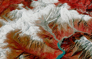
Batura Glacier, Pakistan
The Copernicus Sentinel-2 mission takes us over Batura Glacier – one of the largest and longest glaciers in the world, outside of the polar regions.
Zoom in to see this image at its full resolution or click on the circles to learn more about the features in it.
Located in the upper Hunza Valley, in the Gilgit-Baltistan region of Pakistan, the Batura Glacier is visible in the centre of the image and is approximately 57 km long. It flows from west to east and feeds the Hunza River in north Pakistan, then joins the Gilgit and Naltar Rivers before it flows into the Indus River.
The lower portions of the Batura Glacier feature a grey sea of rocks and gravelly moraine (an accumulation of rocks and sediment carried down by the glacier often caused by avalanches). The glacier has a mean ice thickness of around 150 m, with the lower parts of the glacier holding most of its mass.
This false-colour composite image uses the near-infrared channel of the Copernicus Sentinel-2 mission to highlight vegetation, which appears in red. Batura is bordered by several villages and pastures with herds of sheep, goats and cows where roses and juniper trees are quite common. In the upper-right of the image, pockets of cultivated vegetation alongside the Gilgit and Hunza rivers can be spotted.
Batura Glacier is located just north of the Batura Muztagh, a sub-range of the Karakoram mountain range, which includes the massifs of the Batura Sar, the 25th highest mountain on Earth standing at 7795 m, and Passu Sar at 7478 m.
Glacier shrinkage is a prominent sign of ongoing climate change. However, unlike many glaciers around the world, the glaciers residing in the mountain ranges in Karakoram are not responding to global warming. Their retreating is less than the global average, and in some cases, are either stable or growing. This anomalous behaviour of the region’s glaciers has been coined the ‘Karakoram Anomaly’.
Scientists typically measure the motions of glaciers with ground-based measurements. Because of the rugged terrain and challenges involved in field studies, long-term ground observational data on Karakoram is sparse. Satellites can help monitor changes in glacier mass, extents, trace area and length of glacier changes through time and derive surface velocity. Learn more about how Copernicus Sentinel-2 can help enhance glacier monitoring.
This image, captured on 13 August 2021, is also featured on the Earth from Space video programme.