About ESA
The European Space Agency (ESA) is Europe’s gateway to space. Its mission is to shape the development of Europe’s space capability and ensure that investment in space continues to deliver benefits to the citizens of Europe and the world.
Highlights


Latest


Space in Member States
Find out more about space activities in our 23 Member States, and understand how ESA works together with their national agencies, institutions and organisations.
 Germany
 Austria
 Belgium
 Denmark
 Spain
Spain
 Estonia
 Finland
 France
 Greece
 Hungary
 Ireland
 Italy
Italy
 Luxembourg
 Norway
 The Netherlands
 Poland
 Portugal
 Czechia
 Romania
 United Kingdom
 Slovenia
 Sweden
 Switzerland
Science & Exploration
Exploring our Solar System and unlocking the secrets of the Universe
Go to topicAstronauts


Latest


Enabling & Support
Making space accessible and developing the technologies for the future
Go to topicLatest


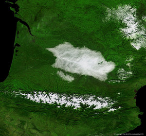
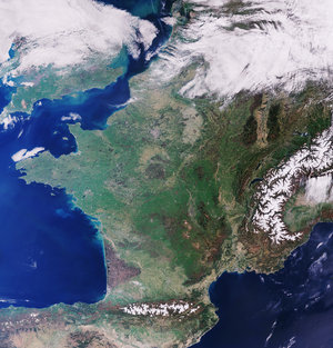
Snowy Pyrenees
The Copernicus Sentinel-2 mission takes us over the Pyrenees Mountains in southwest Europe. The mountain range forms a natural border between France and Spain with the small, landlocked country of Andorra sandwiched in between.
Zoom in to see this image at its full 10 m resolution or click on the circles to learn more about the features in it.
Stretching from the shores of the Mediterranean Sea on the east to the Bay of Biscay (Atlantic Ocean) on the west, this international mountain range is 430 km long. The area pictured in this image, captured on 30 January 2022, spans around 120 km from the village of Escallare in the east to Panticosa to the west.
Located in the Spanish province of Huesca in the Posets-Maladeta Natural Park lies Pico de Aneto, the highest mountain peak in the Pyrenees. It rises to an elevation of 3404 m and is also the third-highest mountain in Spain. Click on the circle in the image to take a closer look at Pico de Aneto.
Geological studies have revealed that the Pyrenees Mountains have been around for longer than the Alps, with their sediments first deposited in coastal basins during the Paleozoic and Mesozoic eras. The entire mountain range formed due to the upwelling of large sedimentary rocks by the collision of the Iberian and the Eurasian plate around 100 to 150 million years ago, followed by intense erosion from ice and water.
Snow covers many of the peaks year-round, especially those in the centre-section of the chain. The western Pyrenees typically receive greater precipitation than the eastern Pyrenees owing to moisture blowing in from the Atlantic Ocean. The mountain range is also home to several small glaciers, as well as many mountain lakes and some of the highest waterfalls in Europe including Gavarnie Falls which, at 422 m, is France’s highest waterfall.
Few people live at the Pyrenees’ highest elevations; however, Andorra is nestled among peaks near the eastern end of the chain (not visible in the image). With an area of around 468 sq km, Andorra is the sixth smallest country in Europe.
The Copernicus Sentinel-2 mission is designed to play a key role in mapping differences in land cover to understand the landscape, map how it is used and monitor changes over time. As well as providing detailed information about Earth’s vegetation, it can also systematically map different classes of cover such as forest, grassland, water surfaces and artificial cover like roads and buildings.
This image is also featured on the Earth from Space video programme.