About ESA
The European Space Agency (ESA) is Europe’s gateway to space. Its mission is to shape the development of Europe’s space capability and ensure that investment in space continues to deliver benefits to the citizens of Europe and the world.
Highlights


Latest


Space in Member States
Find out more about space activities in our 23 Member States, and understand how ESA works together with their national agencies, institutions and organisations.
 Germany
 Austria
 Belgium
 Denmark
 Spain
Spain
 Estonia
 Finland
 France
 Greece
 Hungary
 Ireland
 Italy
Italy
 Luxembourg
 Norway
 The Netherlands
 Poland
 Portugal
 Czechia
 Romania
 United Kingdom
 Slovenia
 Sweden
 Switzerland
Science & Exploration
Exploring our Solar System and unlocking the secrets of the Universe
Go to topicAstronauts


Latest


Enabling & Support
Making space accessible and developing the technologies for the future
Go to topicLatest


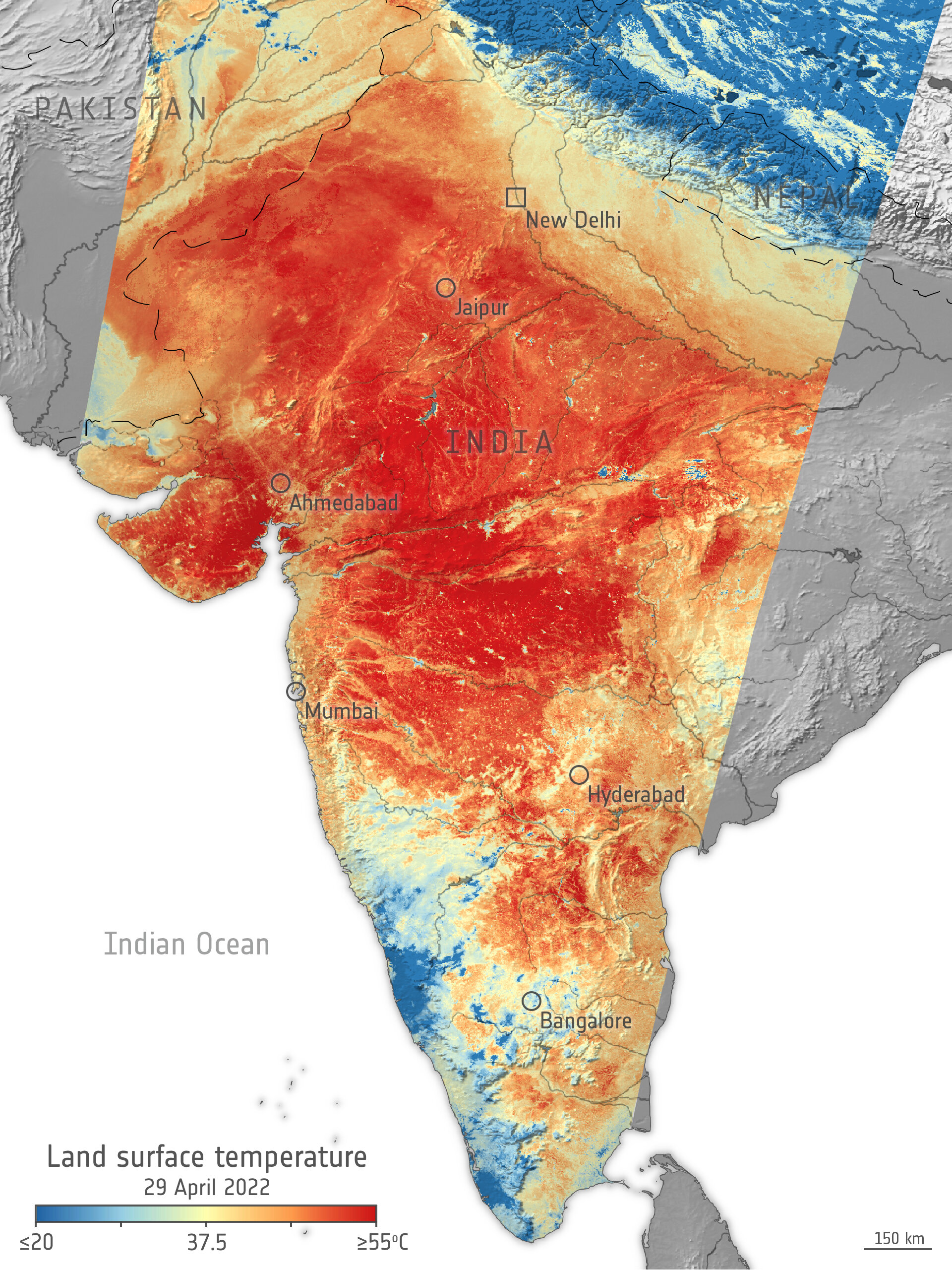
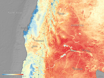
Heatwave across India
India is currently facing a prolonged heatwave, with temperatures exceeding 42°C in numerous cities across the country. This comes just weeks after India recorded its hottest March since the country’s meteorological department began its records over 120 years ago. This image, produced using data from the Copernicus Sentinel-3 mission, shows the land surface temperature across most of the nation.
According to the India Meteorological Department, maximum air temperatures reached 43-46°C over most parts of Rajasthan, Vidarbha, Madhya Pradesh and East Uttar Pradesh; in many parts over Gujarat, interior Odisha; and in some parts of Madhya Maharashtra on 28 April. Forecasters warned that heatwave conditions are expected to continue until 2 May.
Experts at the Indian Institute of Technology’s Water and Climate Lab stated that, in recent years, the number of Indian states hit by heatwaves has increased, as extreme temperatures become more frequent.
Owing to the absence of cloud cover on 29 April (10:30 local time), the Sentinel-3 mission was able to obtain an accurate measurement of the land surface temperature of the ground, which exceeded 60°C in several areas. The data shows that surface temperature in Jaipur and Ahmedabad reached 47°C, while the hottest temperatures recorded are southeast and southwest of Ahmedabad (visible in deep red) with maximum land surface temperatures of around 65°C.
The map was generated by using the mission’s Sea and Land Surface Temperature Radiometer instrument. While weather forecasts use predicted air temperatures, this satellite instrument measures the real amount of energy radiating from Earth. Therefore, the map shows the actual temperature of the land’s surface pictured here, which is usually significantly hotter than air temperatures.
Sentinel-3 can monitor wildfires, map the way the land is used, provide indices of vegetation state, as well as measure the temperature, colour and height of the sea surface. For more information on the Copernicus Sentinel-3 mission, click here.