About ESA
The European Space Agency (ESA) is Europe’s gateway to space. Its mission is to shape the development of Europe’s space capability and ensure that investment in space continues to deliver benefits to the citizens of Europe and the world.
Highlights


Latest


Space in Member States
Find out more about space activities in our 23 Member States, and understand how ESA works together with their national agencies, institutions and organisations.
 Germany
 Austria
 Belgium
 Denmark
 Spain
Spain
 Estonia
 Finland
 France
 Greece
 Hungary
 Ireland
 Italy
Italy
 Luxembourg
 Norway
 The Netherlands
 Poland
 Portugal
 Czechia
 Romania
 United Kingdom
 Slovenia
 Sweden
 Switzerland
Science & Exploration
Exploring our Solar System and unlocking the secrets of the Universe
Go to topicAstronauts


Latest


Enabling & Support
Making space accessible and developing the technologies for the future
Go to topicLatest


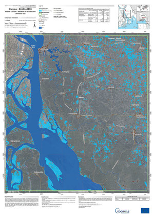
Copernicus Sentinel-1 maps Bangladesh flood
Bangladesh is no stranger to heavy rain, but this year the northeast region is being subjected to the highest rainfall it has seen in more than a century. Days of heavy rain at the beginning of monsoon season have caused widespread flooding, leaving millions stranded and vast areas affected. This flooding has come shortly after a pre-monsoon flood that badly affected the same region a month ago.
The country's Flood Forecasting and Warning Center has reported that major rivers in the districts of Sylhet and Sunamganj have swollen to dangerously high levels because of heavy rain. The government has deployed armed forces across the region to speed up flood rescue and relief efforts.
Space is on hand to help too. The International Charter Space and Major Disasters has been triggered to respond to the disaster. The services take advantage of observations from several satellites and provide on-demand mapping to help civil protection authorities and the international humanitarian community in the face of major emergencies. Europe’s Copernicus Sentinel-1 mission is being used to map the extent of the floods. The satellite radar’s ability to ‘see’ through clouds and rain, and in darkness, makes it particularly useful for monitoring floods. The animation uses Sentinel-1 images that were acquired on 4 May, 16 May, 28 May, 9 June and 21 June, to show how the flood is affecting the region.