About ESA
The European Space Agency (ESA) is Europe’s gateway to space. Its mission is to shape the development of Europe’s space capability and ensure that investment in space continues to deliver benefits to the citizens of Europe and the world.
Highlights


Latest


Space in Member States
Find out more about space activities in our 23 Member States, and understand how ESA works together with their national agencies, institutions and organisations.
 Germany
 Austria
 Belgium
 Denmark
 Spain
Spain
 Estonia
 Finland
 France
 Greece
 Hungary
 Ireland
 Italy
Italy
 Luxembourg
 Norway
 The Netherlands
 Poland
 Portugal
 Czechia
 Romania
 United Kingdom
 Slovenia
 Sweden
 Switzerland
Science & Exploration
Exploring our Solar System and unlocking the secrets of the Universe
Go to topicAstronauts


Latest


Enabling & Support
Making space accessible and developing the technologies for the future
Go to topicLatest


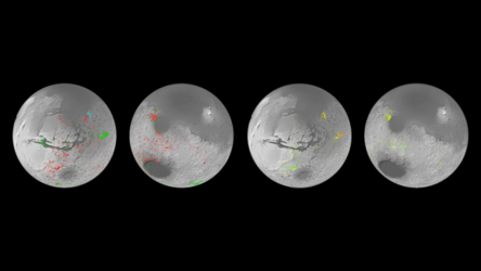
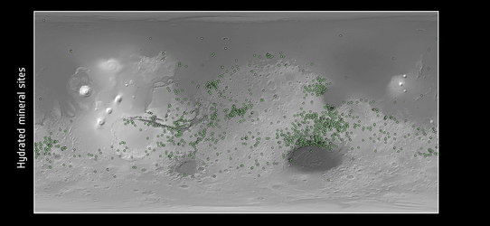
Global map of hydrated minerals on Mars
Data from two Mars missions have been used to create the first detailed global map of hydrated mineral deposits on Mars. These minerals are predominately clays and salts, and can be used to tell the history of water in the planet’s various regions. For the most part, the clays were created on Mars during its early wet period, whereas many of the salts that are still visible today were produced as the water gradually dried up.
The map has been painstakingly created over the last decade using data from ESA’s Mars Express Observatoire pour la Mineralogie, l’Eau, les Glaces et l’Activité (OMEGA) instrument and NASA’s Mars Reconnaissance Orbiter Compact Reconnaissance Imaging Spectrometer for Mars (CRISM) instrument.
Various landing sites and areas of interest are shown on the map. Mawrth Vallis is an ancient water outflow channel that is rich in clays. Oxia Planum is another clay-rich region and has been selected as the landing site for ESA’s Rosalind Franklin rover. Meridiani Planum straddles the martian equator and was the landing spot for NASA’s Mars Exploration Rover Opportunity in 2004. Valles Marineris is one of the largest canyons in the Solar System. Gale crater and Jezero crater were the landing sites of NASA’s Curiosity and Perseverance rovers in 2012 and 2020 respectively.
The clays shown on the map include iron and magnesium phyllosilicates, zeolites and aluminosilicate clays. The salts shown are carbonates made of carbon and oxygen.