About ESA
The European Space Agency (ESA) is Europe’s gateway to space. Its mission is to shape the development of Europe’s space capability and ensure that investment in space continues to deliver benefits to the citizens of Europe and the world.
Highlights


Latest


Space in Member States
Find out more about space activities in our 23 Member States, and understand how ESA works together with their national agencies, institutions and organisations.
 Germany
 Austria
 Belgium
 Denmark
 Spain
Spain
 Estonia
 Finland
 France
 Greece
 Hungary
 Ireland
 Italy
Italy
 Luxembourg
 Norway
 The Netherlands
 Poland
 Portugal
 Czechia
 Romania
 United Kingdom
 Slovenia
 Sweden
 Switzerland
Science & Exploration
Exploring our Solar System and unlocking the secrets of the Universe
Go to topicAstronauts


Latest


Enabling & Support
Making space accessible and developing the technologies for the future
Go to topicLatest


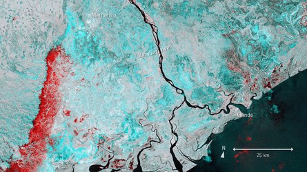
Inhambane Bay, Mozambique
Inhambane Bay, in southeast Mozambique, is featured in this true-colour image captured by the Copernicus Sentinel-2 mission.
Zoom in to see this image at its full 10 m resolution or click on the circles to learn more about the features in it.
Inhambane Bay is a deep inlet into which the small Mutamba River flows. In the north of the bay, where the waters exit into the Mozambique Channel, an arm of the Indian Ocean, different water depths can be identified in tones of green and blue.
Two small islands can be seen in Inhambane Bay: Ilha dos Porcos (Pig Island) in the north and Ilha dos Ratos (Rat Island) in the south. On one side of the bay lies the historical city of Inhambane, capital of the Inhambane Province, while the sister city of Maxixe, the economic capital of Inhambane, sits across from it. The province is the second largest grower of cashews, after Nampula, and it also produces coconut and citrus fruits.
The region belongs to the Southern Zanzibar–Inhambane coastal forest mosaic, a tropical forest ecoregion of east Africa. The ecoregion stretches around 50 km inwards from the coast and supports a variety of habitats including forest, savanna and swamps.
The long coastline of Inhambane supports fishing activities while the stunning beaches of Barra and Tofo, located on the opposite side of the peninsula, are popular seaside destinations. The coastline is also dotted with coral reefs making it a popular region for scuba diving and snorkelling. The waters off the coast are also famed as one of the last remaining populations of dugong in Mozambique.
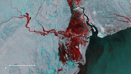
Mozambique’s extensive coastline heightens the country’s vulnerability to tropical cyclones that develop in the Indian Ocean as well as storm surge flooding. More than half of the population lives in low lying coastal areas, putting communities at risk. Inhambane Bay was dangerously close to where Cyclone Idai made landfall in 2019 causing widespread destruction to the country.
Satellites orbiting Earth can provide indispensable up-to-date information to observe such events, and, importantly, to map flooded areas for response teams facing these dire situations. This image was captured by the Copernicus Sentinel-2 mission which is based on a constellation of two satellites, both orbiting Earth at an altitude of 786 km but 180° apart. This configuration optimises coverage and global revisit times.
This image is also featured on the Earth from Space video programme.