About ESA
The European Space Agency (ESA) is Europe’s gateway to space. Its mission is to shape the development of Europe’s space capability and ensure that investment in space continues to deliver benefits to the citizens of Europe and the world.
Highlights


Latest


Space in Member States
Find out more about space activities in our 23 Member States, and understand how ESA works together with their national agencies, institutions and organisations.
 Germany
 Austria
 Belgium
 Denmark
 Spain
Spain
 Estonia
 Finland
 France
 Greece
 Hungary
 Ireland
 Italy
Italy
 Luxembourg
 Norway
 The Netherlands
 Poland
 Portugal
 Czechia
 Romania
 United Kingdom
 Slovenia
 Sweden
 Switzerland
Science & Exploration
Exploring our Solar System and unlocking the secrets of the Universe
Go to topicAstronauts


Latest


Enabling & Support
Making space accessible and developing the technologies for the future
Go to topicLatest


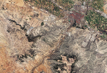
Zaragoza, Spain
The province of Zaragoza, in northeast Spain, is featured in this image captured by the Copernicus Sentinel-2 mission.
Together with the provinces of Huesca and Teruel, Zaragoza formed the old kingdom of Aragon. Its capital, also called Zaragoza (not visible in this image) is home to around half of Aragon’s population.
The Ebro River can be seen winding its way through the province from west to east in this image. Between its source in the Cantabrian Mountains in the northwest and its delta on the Mediterranean coast, the Ebro River is fed by more than 200 tributaries as it flows 910 km across much of northern Spain.
In an otherwise arid region, with scarce annual rainfall of less than 380 to 460 mm, irrigation in the Ebro basin is extremely important. The La Loteta reservoir, popular for kite surfing, was designed to regulate the flow of the Aragon Imperial Canal and is visible in turquoise in the bottom-left of the image.
Many agricultural fields in the valleys surrounding the Ebro River can be seen in the image. Cereals, especially wheat and barley, dominate the economy, followed by corn, stock raising and fruit. Different types of agricultural fields can be identified by their shapes. For example, circular shapes in the bottom-left of the image are centre-pivot irrigation fields – where equipment rotates around a central pivot and crops are watered with sprinklers.
The nearby mountains, largely devoid of vegetation, can be seen north of the river. These dry and mountainous areas are the least populated of the region.
Copernicus Sentinel-2 is based on a constellation of two identical satellites in the same orbit. Its five-day revisit frequency and its global coverage offer excellent opportunities for both regional and global agriculture monitoring. Copernicus helps assess agricultural land use and trends, crop conditions and yield forecasts. It also supports input management, farm management recording and irrigation management.
This image is also featured on the Earth from Space video programme.