About ESA
The European Space Agency (ESA) is Europe’s gateway to space. Its mission is to shape the development of Europe’s space capability and ensure that investment in space continues to deliver benefits to the citizens of Europe and the world.
Highlights


Latest


Space in Member States
Find out more about space activities in our 23 Member States, and understand how ESA works together with their national agencies, institutions and organisations.
 Germany
 Austria
 Belgium
 Denmark
 Spain
Spain
 Estonia
 Finland
 France
 Greece
 Hungary
 Ireland
 Italy
Italy
 Luxembourg
 Norway
 The Netherlands
 Poland
 Portugal
 Czechia
 Romania
 United Kingdom
 Slovenia
 Sweden
 Switzerland
Science & Exploration
Exploring our Solar System and unlocking the secrets of the Universe
Go to topicAstronauts


Latest


Enabling & Support
Making space accessible and developing the technologies for the future
Go to topicLatest


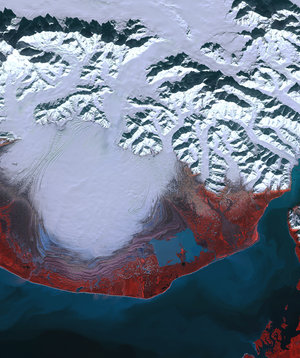
The moraines of Malaspina
The remarkable moraine patterns of Malaspina Glacier – the largest piedmont glacier in the world – are featured in this false-colour image acquired by Copernicus Sentinel-2.
Zoom in to see this image at its full 10 m resolution or click on the circles to learn more about the features in it.
Malaspina Glacier is located west of Yakutat Bay in southeast Alaska, US. Covering an area of around 2900 sq km, the glacier flows for around 80 km along the southern base of Mount St. Elias and is around 300 m thick.
Malaspina flows faster than the piedmont glaciers in Antarctica and Greenland. Piedmont glaciers flow from a steeply sided valley, where the ice is constrained by mountains, onto a flat plain. The change in environment from narrow to wide creates the piedmont’s signature rounded lobe.
This Sentinel-2 image shows the central lobe of the glacier surging towards the sea. This image has been processed using the near-infrared channel to highlight vegetation in bright red. The wavy lines around the lower half of the glacier are rock, soil and other debris that have been deposited by the glacier – called moraines.
The colour of soil varies from light to dark brown in the image, while ice and snow appear bright white. The low Sun level at Alaska’s high latitudes during this season is evident by the shadows cast north by the Elias Mountains. Clear waters of the Pacific Ocean appear dark blue, while turbid waters appear in cyan.
The Malaspina Glacier is widely studied by scientists around the world. Its vulnerability to climate change and its cycles of surges and retreats were studied by scientists using Copernicus and Landsat data. They found that in the event of sea level rise, induced by climate change, seawater could cause major changes in the glacier’s terminus and lead to severe impacts on habitats in the area.
This image, also featured on the Earth from Space video programme, was captured on 4 July 2022.