About ESA
The European Space Agency (ESA) is Europe’s gateway to space. Its mission is to shape the development of Europe’s space capability and ensure that investment in space continues to deliver benefits to the citizens of Europe and the world.
Highlights


Latest


Space in Member States
Find out more about space activities in our 23 Member States, and understand how ESA works together with their national agencies, institutions and organisations.
 Germany
 Austria
 Belgium
 Denmark
 Spain
Spain
 Estonia
 Finland
 France
 Greece
 Hungary
 Ireland
 Italy
Italy
 Luxembourg
 Norway
 The Netherlands
 Poland
 Portugal
 Czechia
 Romania
 United Kingdom
 Slovenia
 Sweden
 Switzerland
Science & Exploration
Exploring our Solar System and unlocking the secrets of the Universe
Go to topicAstronauts


Latest


Enabling & Support
Making space accessible and developing the technologies for the future
Go to topicLatest


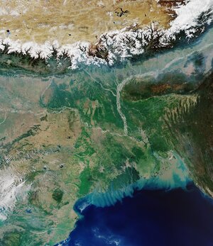
Earth from Space: Kolkata, India
Kolkata, formerly Calcutta, is featured in this optical image, captured by the Copernicus Sentinel-2 mission.
Zoom in to explore this image at its full 10 m resolution or click on the circles to learn more about the features in it.
Kolkata, visible in grey in the centre of the image, is one of India’s largest cities with over 14 million inhabitants. Part of the neighbouring country Bangladesh is also visible in the right.
Kolkata lies on the Hooghly River, which can be seen cutting through the city. The different shades of brown and blue in the water are likely due to the high concentration of sediments. Vast agricultural and aquaculture fields can also be seen, including rice fields and fish ponds, which are distinguishable by their rectangular shapes and the presence of water, particularly in the right side of the image.
The Sundarbans National Park is visible in dark green in the bottom right corner. This protected national reserve, a designated UNESCO World Heritage Site, is home to Bengal tigers and hosts a vast mangrove forest.
Copernicus Sentinel-2 is a two-satellite mission designed to map differences in land cover to understand Earth’s landscape, as well as monitor changes over time. As cities continue to expand, Sentinel-2 can also be used to improve urban and rural planning.