About ESA
The European Space Agency (ESA) is Europe’s gateway to space. Its mission is to shape the development of Europe’s space capability and ensure that investment in space continues to deliver benefits to the citizens of Europe and the world.
Highlights


Latest


Space in Member States
Find out more about space activities in our 23 Member States, and understand how ESA works together with their national agencies, institutions and organisations.
 Germany
 Austria
 Belgium
 Denmark
 Spain
Spain
 Estonia
 Finland
 France
 Greece
 Hungary
 Ireland
 Italy
Italy
 Luxembourg
 Norway
 The Netherlands
 Poland
 Portugal
 Czechia
 Romania
 United Kingdom
 Slovenia
 Sweden
 Switzerland
Science & Exploration
Exploring our Solar System and unlocking the secrets of the Universe
Go to topicAstronauts


Latest


Enabling & Support
Making space accessible and developing the technologies for the future
Go to topicLatest


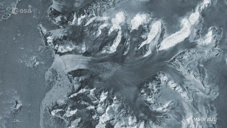
Earth from Space: Graham Coast, Antarctica
The icy landscape of Graham Coast, which lies on the west side of the Antarctic Peninsula, is featured in this Copernicus Sentinel-2 image taken in December 2022.
Zoom in to explore this image at its full resolution.
The Antarctic Peninsula is the northernmost and warmest region of the Antarctic continent. It resembles a 1000-km-long arm, stretching towards the southern tip of South America. The west coast of the peninsula is home to over 100 large glaciers, some of which are visible in this image; from the right: Murphy, Wilkinson, Drummond, Erskine, Widmark, Hugi, Lawrie, Weir and Comrie.
Like many places on Earth, the region has experienced exceptional atmospheric warming over the last decades. Using satellite data, a team of scientists have measured the speed of glaciers on the peninsula and discovered that in the summer months they are flowing faster than expected.
While some ice melts into the ocean, some breaks off into icebergs. The dark colour of the waters in the image allows us to easily spot many icebergs floating along the coast, as well as fragmented sea ice.
The Biscoe Islands also lie off the coast. The bigger islands visible in the image are the 45-km long Renaud Island on the left and the 29-km long Lavoisier Island in the centre.
The Copernicus Sentinel-2 satellites each carry a high-resolution camera that takes images of Earth’s surface. While there are many advantages to this type of optical instrument, they cannot acquire meaningful images when it is dark or very cloudy. However, Sentinel-2’s wide swath and frequent revisit times increase the chance of imaging when the clouds part, as we see here in this image.