About ESA
The European Space Agency (ESA) is Europe’s gateway to space. Its mission is to shape the development of Europe’s space capability and ensure that investment in space continues to deliver benefits to the citizens of Europe and the world.
Highlights


Latest


Space in Member States
Find out more about space activities in our 23 Member States, and understand how ESA works together with their national agencies, institutions and organisations.
 Germany
 Austria
 Belgium
 Denmark
 Spain
Spain
 Estonia
 Finland
 France
 Greece
 Hungary
 Ireland
 Italy
Italy
 Luxembourg
 Norway
 The Netherlands
 Poland
 Portugal
 Czechia
 Romania
 United Kingdom
 Slovenia
 Sweden
 Switzerland
Science & Exploration
Exploring our Solar System and unlocking the secrets of the Universe
Go to topicAstronauts


Latest


Enabling & Support
Making space accessible and developing the technologies for the future
Go to topicLatest


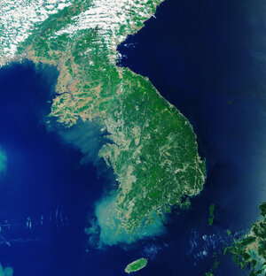
Earth from Space: Seoul, South Korea
South Korea’s capital city, Seoul, and surroundings are featured in this image, captured by the Copernicus Sentinel-2 mission on 21 February 2023.
Zoom in to explore this image at its full 10 m resolution or click on the circles to learn more.
Situated some 50 km south of the North Korean border, the metropolitan area of Seoul appears as the grey area in the centre of the image.
The Han River runs through the city, and to the right of the image it can be seen partly covered by ice. It is one of the biggest rivers in the Korean peninsula. It flows westward through Seoul into the Yellow Sea, named so because of the yellowish sand that colours its water.
Seoul is surrounded by forested mountains, which appear brown in this wintery image. Bukhansan National Park lies just north of the city. The park is like an island, acting as a big green lung for the surrounding urban environment.
West of Seoul lies the coastal city of Incheon, which serves as Seoul’s chief port. The Incheon International Airport, South Korea’s main airport, is clearly visible in the image to the west of the large artificial island.
The artificial seawall of the Sihwa Lake tidal power station, which creates a basin along the coast, can be spotted as a light brown line towards the bottom of the image. It is the world’s largest tidal power station and it makes use of strong tides that can lead to water level differences of more than six metres. Signs of these tidal forces can be seen in the image, mainly in the form of extensive sandy banks along the coast.
There are also numerous oyster farms that also benefit from the strong tides. They are visible as blue rectangles at the very bottom of the image, in the Yellow Sea.