About ESA
The European Space Agency (ESA) is Europe’s gateway to space. Its mission is to shape the development of Europe’s space capability and ensure that investment in space continues to deliver benefits to the citizens of Europe and the world.
Highlights


Latest


Space in Member States
Find out more about space activities in our 23 Member States, and understand how ESA works together with their national agencies, institutions and organisations.
 Germany
 Austria
 Belgium
 Denmark
 Spain
Spain
 Estonia
 Finland
 France
 Greece
 Hungary
 Ireland
 Italy
Italy
 Luxembourg
 Norway
 The Netherlands
 Poland
 Portugal
 Czechia
 Romania
 United Kingdom
 Slovenia
 Sweden
 Switzerland
Science & Exploration
Exploring our Solar System and unlocking the secrets of the Universe
Go to topicAstronauts


Latest


Enabling & Support
Making space accessible and developing the technologies for the future
Go to topicLatest


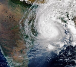
Earth from Space: Cyclone Mocha
The Copernicus Sentinel-3 mission captured this image of the powerful Cyclone Mocha on 13 May 2023 as it made its way across the Bay of Bengal heading northeast towards Bangladesh and Myanmar.
Zoom in to explore this image at its full resolution or click on the circles to learn more.
Cyclone Mocha originated in the Indian Ocean, and it gradually intensified while moving towards the Bay of Bengal. Winds topped 280 km per hour, making it one the strongest storms on record in the North Indian Ocean, similar to Cyclone Fani, which hit the same area in May 2019.
Although the storm weakened slightly as it approached Myanmar and Bangladesh, it caused widespread destruction as it made landfall on 14 May.
With thousands of people losing their houses, infrastructure seriously damaged and croplands inundated, both the International Charter Space and Major Disasters and the Copernicus Emergency Mapping Service were triggered to supply maps based on satellite data to help civil protection authorities and the international humanitarian community with their emergency response efforts.
Satellites orbiting Earth can provide indispensable up-to-date information to observe such events, as shown here from Copernicus Sentinel-3. The mission is designed to measure, monitor and understand large-scale global dynamics and provides essential information in near-real time for ocean and weather forecasting.
Acquired with the Ocean and Land Colour Instrument, this wide view covers an area of over 2000 km from north to south. The storm is estimated to be more than 1000 km across.
In the cloud-free portion on top of the image we can see parts of India, Nepal, Bangladesh and Myanmar and the entire country of Bhutan. The white snow-capped mountains of the eastern part of the Himalayas, including Mount Everest, the highest mountain on the planet, are clearly visible. The Tibetan Plateau – part of China – appear in brownish colours owing to the absence of vegetation.