Rhodes wildfire forces thousands to flee
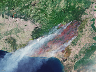
Wildfires burning on the Greek island of Rhodes have forced the evacuation of thousands of people as flames have spread from the island’s mountainous region to the coast. The Copernicus Sentinel-2 mission captured this image of the ongoing blaze yesterday 23 July 2023.
The image has been processed by combining natural colour bands with shortwave-infrared information to highlight the fire front. The image shows the extent of the burned area (visible in shades of brown) in the central part of the island, with a preliminary estimate of 11 000 hectares lost at the time of acquisition.
Residents and tourists took refuge in schools and temporary shelters on Sunday, with many evacuated on private boats, as flames threatened coastal villages and holiday resorts.
In response to the fires, the Copernicus Emergency Mapping Service was activated. The service uses satellite observations to help civil protection authorities and, in cases of disaster, the international humanitarian community, respond to emergencies.
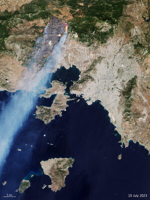
Air temperatures over the past week have exceeded 40°C in many parts of Greece. In addition to Rhodes, wildfires are also burning near Athens and on the island of Corfu.
The Sentinel-2 mission is based on a constellation of two identical satellites, each carrying an innovative wide swath high-resolution multispectral imager with 13 spectral bands for monitoring changes in Earth’s land and vegetation.