About ESA
The European Space Agency (ESA) is Europe’s gateway to space. Its mission is to shape the development of Europe’s space capability and ensure that investment in space continues to deliver benefits to the citizens of Europe and the world.
Highlights


Latest


Space in Member States
Find out more about space activities in our 23 Member States, and understand how ESA works together with their national agencies, institutions and organisations.
 Germany
 Austria
 Belgium
 Denmark
 Spain
Spain
 Estonia
 Finland
 France
 Greece
 Hungary
 Ireland
 Italy
Italy
 Luxembourg
 Norway
 The Netherlands
 Poland
 Portugal
 Czechia
 Romania
 United Kingdom
 Slovenia
 Sweden
 Switzerland
Science & Exploration
Exploring our Solar System and unlocking the secrets of the Universe
Go to topicAstronauts


Latest


Enabling & Support
Making space accessible and developing the technologies for the future
Go to topicLatest


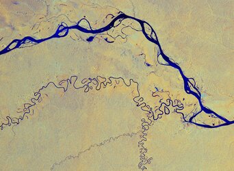
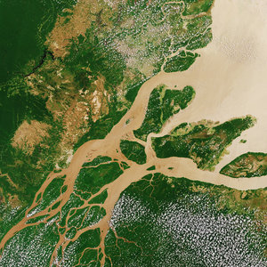
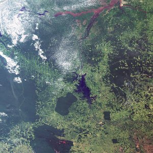
Earth from Space: The Amazon plume
The Copernicus Sentinel-3 mission takes us over northern Brazil, where the Amazon River meets the Atlantic Ocean.
Zoom in to explore this image at its full resolution or click on the circles to learn more.
Originating in the Andes, the Amazon River flows east, traversing six South American countries before reaching the northeast coast of Brazil, where it empties into the Atlantic. The sediment-laden river appears brown as it flows to the open ocean in the upper centre of the image.
The coast is surrounded by a muddy-brownish plume of suspended sediment, carried from upstream to the maze of channels constituting the 270-km-wide mouth of the Amazon. Discharge from the Amazon River, the Amazon plume, accounts for around 20% of the global input of freshwater into the ocean from Earth's land surfaces.
The Amazon has over 1000 tributaries, some of which are visible as thin, winding lines entering the river from the south, including the Tapajos River to the west and, further downstream, the Xingu River. The dark colour of these sediment-poor tributaries contrasts with the brownish sediment-rich Amazon waters.
The Tapajós-Xingu area is an important moist forest ecoregion. However, the Transamazon Highway, discernible as a brown line traversing this area, has spurred urbanisation.
The colour of the land varies, ranging from the deep green of dense, untouched vegetation to various tones of brown, highlighting the contrast between the rainforest and sprawling cultivation ̶ the fishbone-like patterns particularly visible along the highway.
Light green hues across the image denote agricultural areas, which were once covered by rainforest. The somewhat geometric shapes, which appear dark green and brown, result from forest clear-cutting.
Rainforests worldwide are disappearing at an alarming rate, a matter of great concern owing to their pivotal role in the global climate, and their status as habitats for a wide range of plants, animals and insects.
With their unique view from space, Earth observation satellites like Copernicus Sentinel-3 are instrumental in highlighting the vulnerability of rainforests by documenting, on a large scale, the extent and damage due to deforestation, particularly in remote regions.