About ESA
The European Space Agency (ESA) is Europe’s gateway to space. Its mission is to shape the development of Europe’s space capability and ensure that investment in space continues to deliver benefits to the citizens of Europe and the world.
Highlights


Latest


Space in Member States
Find out more about space activities in our 23 Member States, and understand how ESA works together with their national agencies, institutions and organisations.
 Germany
 Austria
 Belgium
 Denmark
 Spain
Spain
 Estonia
 Finland
 France
 Greece
 Hungary
 Ireland
 Italy
Italy
 Luxembourg
 Norway
 The Netherlands
 Poland
 Portugal
 Czechia
 Romania
 United Kingdom
 Slovenia
 Sweden
 Switzerland
Science & Exploration
Exploring our Solar System and unlocking the secrets of the Universe
Go to topicAstronauts


Latest


Enabling & Support
Making space accessible and developing the technologies for the future
Go to topicLatest


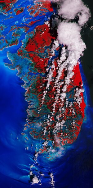
Earth from Space: Seychelles
The Copernicus Sentinel-2 mission takes us over part of the Seychelles, an island republic in the western Indian Ocean.
Zoom in to explore this image at its full 10 m resolution or click on the circles to learn more.
Positioned about 1600 km east of Kenya and about 1100 km northeast of Madagascar, the Seychelles archipelago comprises around 115 small islands – spread across 90 000 sq km of ocean – with only eight being inhabited by humans.
Some of these islands are visible in the image. The turquoise hues along the shores depict clear, shallow waters dotted by coral reefs, which contrast with the darker waters of the deep Indian Ocean.
One of the world’s smallest countries, the archipelago consists of two main island groups: the central, mountainous, granitic islands, and the outer, flat, coralline islands.
The two largest islands of the archipelago are featured in this image: Mahé (bottom left) and Praslin (top right). Both belong to the granitic island group.
Mahé is home to the capital Victoria, clear to see on the northeastern coast. Victoria serves as the only port in the Seychelles, capable of accommodating several ships at one time. The white dots in the water show vessels around the port. The Seychelles International Airport is visible to the west.
As evident from the image, lush vegetation covers much of the island, mainly protected by national parks. The Morne Seychellois National Park is the largest, extending approximately 3000 hectares, encompassing over 20% of Mahé’s land. The park features mangroves, tropical jungles and mountains, including the 900 m-high Morne Seychellois – the highest peak in the whole archipelago.
Many low-lying islands, especially the coralline islands, and most coastal areas are at risk of disappearing or becoming uninhabitable due to sea-level rise, driven by the climate crisis. Earth-observing satellites are used to monitor global and regional sea-level change and coastal erosion and to assess vulnerability. These observations support adaptation and resilience strategies to mitigate the growing threat posed by sea-level rise.