About ESA
The European Space Agency (ESA) is Europe’s gateway to space. Its mission is to shape the development of Europe’s space capability and ensure that investment in space continues to deliver benefits to the citizens of Europe and the world.
Highlights


Latest


Space in Member States
Find out more about space activities in our 23 Member States, and understand how ESA works together with their national agencies, institutions and organisations.
 Germany
 Austria
 Belgium
 Denmark
 Spain
Spain
 Estonia
 Finland
 France
 Greece
 Hungary
 Ireland
 Italy
Italy
 Luxembourg
 Norway
 The Netherlands
 Poland
 Portugal
 Czechia
 Romania
 United Kingdom
 Slovenia
 Sweden
 Switzerland
Science & Exploration
Exploring our Solar System and unlocking the secrets of the Universe
Go to topicAstronauts


Latest


Enabling & Support
Making space accessible and developing the technologies for the future
Go to topicLatest


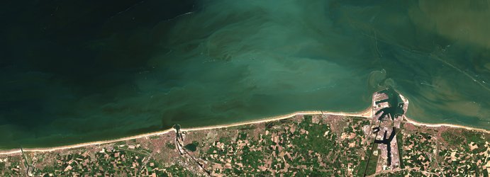
Earth from Space: Adriatic bloom
This Copernicus Sentinel-2 image captures algal bloom swirls in the north Adriatic Sea, along the coast of Italy.
Zoom in to explore this image at its full 10 m resolution or click on the circles to learn more.
An algal bloom describes the rapid growth of phytoplankton – microscopic marine plants that drift on or near the sea surface. The chlorophyll that phytoplankton use for photosynthesis collectively tints the surrounding waters, providing a means of detecting these tiny organisms from space with certain satellite sensors.
With its 13 spectral channels, Copernicus Sentinel-2’s imager can be used to detect the extent and evolution of these blooms. In this image from 12 August 2024, the emerald-green streaks, eddies and whirls of the bloom, mixed by winds and currents, are clearly visible and cover an area of around 9000 sq km.
Algal blooms are a natural and essential part of ocean life. Warm weather, with surface water temperatures reaching 29°C, and calm seas in July and August 2024 led to an increase in mucilage in the Adriatic Sea. Here, white threads of mucilage can be spotted across the bloom. Currents and winds contributed to concentrating the mucilage into visible patches along the coast, interfering with fishing activities and making the waters less attractive for swimmers.
Satellite data like those from Sentinel-2 can be used to track the growth and spread of blooms and can help local authorities to implement timely strategies to reduce the impact on tourism and fishing.