About ESA
The European Space Agency (ESA) is Europe’s gateway to space. Its mission is to shape the development of Europe’s space capability and ensure that investment in space continues to deliver benefits to the citizens of Europe and the world.
Highlights


Latest


Space in Member States
Find out more about space activities in our 23 Member States, and understand how ESA works together with their national agencies, institutions and organisations.
 Germany
 Austria
 Belgium
 Denmark
 Spain
Spain
 Estonia
 Finland
 France
 Greece
 Hungary
 Ireland
 Italy
Italy
 Luxembourg
 Norway
 The Netherlands
 Poland
 Portugal
 Czechia
 Romania
 United Kingdom
 Slovenia
 Sweden
 Switzerland
Science & Exploration
Exploring our Solar System and unlocking the secrets of the Universe
Go to topicAstronauts


Latest


Enabling & Support
Making space accessible and developing the technologies for the future
Go to topicLatest


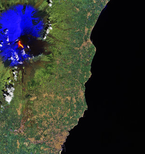
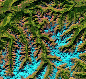
Earth from Space: Clouds or snow?
These two images acquired by Copernicus Sentinel-2 highlight how the mission can help distinguish between clouds and snow.
The Copernicus Sentinel-2 satellites each carry a high-resolution multispectral imager to provide optical images in 13 spectral bands, from the visible to the shortwave-infrared region of the electromagnetic spectrum. These two images, from August 2024, capture the same area over the Australian Alps in southeast Australia, but have been produced using the instrument’s different spectral channels.
On the left, the true-colour image shows the area as the human eye would see it. As we can see, the area is covered with clouds. The long, straight lines are contrails from aircraft, most likely travelling along the busy route between Canberra and Melbourne.
The image features a number of snow-covered and cloud-covered areas, but how can we distinguish them? Both appear white, as they both reflect visible light. This is where different band combinations can help.
The false-colour image on the right includes the shortwave-infrared bands, which highlight snow and clouds differently. Snow and ice appear in electric blue, and water vapour, or clouds, can be seen in white.
By comparing the two images, it is now easy to identify snow in blue on the right and thicker clouds in white towards the centre of the image. Thinner layers of clouds and contrails on the other hand are barely visible.
The task of separating clouds from snow is also a critical classification issue when using Artificial Intelligence (AI) to process satellite images – a field that is rapidly growing. By analysing multispectral images, the newest AI algorithms are learning to distinguish between these two elements.
Satellite missions such as Copernicus Sentinel-2 that can provide observations in multiple spectral bands are key to this task, providing a wealth of information in different views of our planet.