About ESA
The European Space Agency (ESA) is Europe’s gateway to space. Its mission is to shape the development of Europe’s space capability and ensure that investment in space continues to deliver benefits to the citizens of Europe and the world.
Highlights


Latest


Space in Member States
Find out more about space activities in our 23 Member States, and understand how ESA works together with their national agencies, institutions and organisations.
 Germany
 Austria
 Belgium
 Denmark
 Spain
Spain
 Estonia
 Finland
 France
 Greece
 Hungary
 Ireland
 Italy
Italy
 Luxembourg
 Norway
 The Netherlands
 Poland
 Portugal
 Czechia
 Romania
 United Kingdom
 Slovenia
 Sweden
 Switzerland
Science & Exploration
Exploring our Solar System and unlocking the secrets of the Universe
Go to topicAstronauts


Latest


Enabling & Support
Making space accessible and developing the technologies for the future
Go to topicLatest


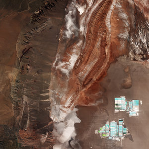
Sentinel-1A–Sentinel-1C cross-satellite interferogram, Atacama Desert
Only launched two months ago and still in the process of being commissioned for service, the Copernicus Sentinel-1C satellite has, remarkably, shown how its radar data can be used to map the shape of Earth’s land surface with extreme precision. These first cross-satellite ‘interferometry’ results assure its ability to monitor subsidence, uplift, glacier flow, and disasters such as landslides and earthquakes.
This cross-satellite interferogram is of the Atacama Desert plateau in northern Chile and was generated from images acquired just one day apart, by Sentinel-1A on 19 January and Sentinel-1C on 20 January. The ‘grey-scale amplitude’ radar image is for reference.
Read full story: Sentinel-1C demonstrates its power to map land deformation