About ESA
The European Space Agency (ESA) is Europe’s gateway to space. Its mission is to shape the development of Europe’s space capability and ensure that investment in space continues to deliver benefits to the citizens of Europe and the world.
Highlights


Latest


Space in Member States
Find out more about space activities in our 23 Member States, and understand how ESA works together with their national agencies, institutions and organisations.
 Germany
 Austria
 Belgium
 Denmark
 Spain
Spain
 Estonia
 Finland
 France
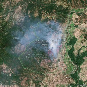
 Greece
 Hungary
 Ireland
 Italy
Italy
 Luxembourg
 Norway
 The Netherlands
 Poland
 Portugal
 Czechia
 Romania
 United Kingdom
 Slovenia
 Sweden
 Switzerland
Science & Exploration
Exploring our Solar System and unlocking the secrets of the Universe
Go to topicAstronauts


Latest


Enabling & Support
Making space accessible and developing the technologies for the future
Go to topicLatest


Earth from Space: Waza National Park, Cameroon
The Copernicus Sentinel-2 mission captures the striking landscape surrounding the Waza National Park in Cameroon.
Zoom in to explore this image at its full 10 m resolution or click on the circles to learn more.
The Waza National Park lies in the most northern region of Cameroon extending between Chad to the east, and Nigeria in the west. The park, which covers an area of 1700 sq km, is only about 10 km from the border of each country.
Here, the Waza National Park is on the left side of the green area at the bottom of the image. It is the country’s most diverse wildlife reserve and is home to lions, elephants, giraffes, antelopes and numerous species of birds. It was declared a Unesco World Heritage biosphere reserve in 1979.
At its western perimeter lies the town of Waza, visible as a small, yellowish area flanked by green land on two sides.
The vast, green zone surrounding the park is the Logone floodplain, one of the numerous floodplains within the Lake Chad basin. The lush green in the image is the result of seasonal flooding of the Logone River, appearing as a winding brown line to the east of the plain, and flowing along the border between Cameroon and Chad.
The ecosystem of this territory is shaped by the cycle of dry and wet seasons. During rainy season, which lasts from mid-May to mid-October, the region is inundated, becoming a temporary wetland that sustains grasses, reeds and seasonal water bodies.
More than 100 000 people live in the area and rely on the timing and the extent of the flood for fishing, grazing and agriculture. Patches of agricultural fields are visible in the image, with the largest at the bottom, left of the Logone River.
This image was acquired in November 2024, when the floodwaters usually start receding, leaving the area green and fertile. Evidence of the coming dry season is already visible: while the park conserves natural vegetation, nearby lands shift towards post-harvest stubble or fallow fields, appearing in brown hues.
On the right, the Chari River, Lake Chad’s principal tributary, appears green. It joins the Logone River to the north, before eventually flowing into Lake Chad (not pictured) further north. At the confluence between Chari and Logone lies N’Djamena, the capital city of Chad, visible as a large grey area at the top of the image.