About ESA
The European Space Agency (ESA) is Europe’s gateway to space. Its mission is to shape the development of Europe’s space capability and ensure that investment in space continues to deliver benefits to the citizens of Europe and the world.
Highlights


Latest


Space in Member States
Find out more about space activities in our 23 Member States, and understand how ESA works together with their national agencies, institutions and organisations.
 Germany
 Austria
 Belgium
 Denmark
 Spain
Spain
 Estonia
 Finland
 France
 Greece
 Hungary
 Ireland
 Italy
Italy
 Luxembourg
 Norway
 The Netherlands
 Poland
 Portugal
 Czechia
 Romania
 United Kingdom
 Slovenia
 Sweden
 Switzerland
Science & Exploration
Exploring our Solar System and unlocking the secrets of the Universe
Go to topicAstronauts


Latest


Enabling & Support
Making space accessible and developing the technologies for the future
Go to topicLatest


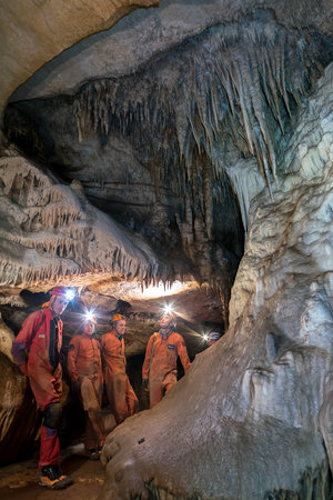
CAVES 2016: Photogrammetry

Photogrammetry is the science of getting precise measurements and three-dimensional data from at least two photographs. This technique can be applied to construct a 3D model of any scene from any source of image, from standard digital cameras to cameras on Earth-orbiting satellites. The 3D models can be analysed to store information on size, volume, shape and morphology of the surveyed areas.
These models were made during the 2016 edition of ESA’s underground astronaut training course CAVES – Cooperative Adventure for Valuing and Exercising human behaviour and performance Skills.
Photogrammetry could be used by astronauts on the surface of other planets, or even underground such as in the lava tubes of Mars for scientists on Earth.
The 3D models are available on Sketchfab at:
https://skfb.ly/PXZ9
https://skfb.ly/QqyJ
Follow the underground adventure on Twitter with via @ESA_CAVES, and on the CAVES blog