About ESA
The European Space Agency (ESA) is Europe’s gateway to space. Its mission is to shape the development of Europe’s space capability and ensure that investment in space continues to deliver benefits to the citizens of Europe and the world.
Highlights


Latest


Space in Member States
Find out more about space activities in our 23 Member States, and understand how ESA works together with their national agencies, institutions and organisations.
 Germany
 Austria
 Belgium
 Denmark
 Spain
Spain
 Estonia
 Finland
 France
 Greece
 Hungary
 Ireland
 Italy
Italy
 Luxembourg
 Norway
 The Netherlands
 Poland
 Portugal
 Czechia
 Romania
 United Kingdom
 Slovenia
 Sweden
 Switzerland
Science & Exploration
Exploring our Solar System and unlocking the secrets of the Universe
Go to topicAstronauts


Latest


Enabling & Support
Making space accessible and developing the technologies for the future
Go to topicLatest


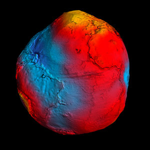
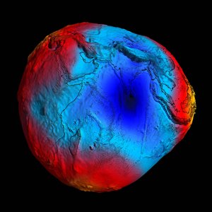
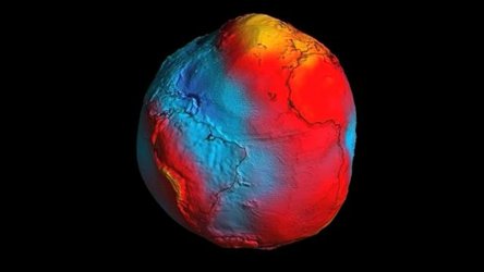
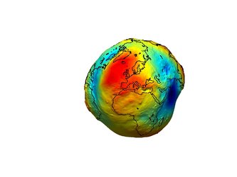
Geoid and ocean currents

Shaped by such things as the rotation of the Earth, the position of mountains, ocean trenches and variations in the density of the Earth's interior, the irregular gravity field shapes the geoid. The geoid represents the shape of a hypothetical ocean surface at rest in response to variations in the Earth's gravity only. External forces such as the wind cause the actual sea surface to deviate from the geoid. Altimetry systems on ERS-2 and Envisat measure sea-surface height. The large-scale current systems flow along lines of equal topography and are focused around the strongest gradients in these sea-surface deviations. Therefore, it is the combination of sea-surface height mapped by altimeters and the knowledge of the precise ocean geoid that will improve our understanding of surface currents and lead to a better knowledge of general ocean circulation patterns - crucial for understanding climate change.