About ESA
The European Space Agency (ESA) is Europe’s gateway to space. Its mission is to shape the development of Europe’s space capability and ensure that investment in space continues to deliver benefits to the citizens of Europe and the world.
Highlights


Latest


Space in Member States
Find out more about space activities in our 23 Member States, and understand how ESA works together with their national agencies, institutions and organisations.
 Germany
 Austria
 Belgium
 Denmark
 Spain
Spain
 Estonia
 Finland
 France
 Greece
 Hungary
 Ireland
 Italy
Italy
 Luxembourg
 Norway
 The Netherlands
 Poland
 Portugal
 Czechia
 Romania
 United Kingdom
 Slovenia
 Sweden
 Switzerland
Science & Exploration
Exploring our Solar System and unlocking the secrets of the Universe
Go to topicAstronauts


Latest


Enabling & Support
Making space accessible and developing the technologies for the future
Go to topicLatest


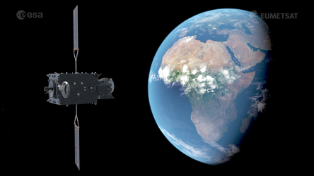
MTG-Imager

Building on the long-standing partnership between ESA and Eumetsat, and the success of both the first generation of Meteosat missions and the subsequent Meteosat Second Generation (MSG) series, Meteosat Third Generation (MTG) is set to take over the reins of providing weather data from geostationary orbit. This third generation of weather satellites not only guarantees the continuity of data for weather forecasting from geostationary orbit for the next two decades, but also offers significant enhancement of the current capabilities.
The MTG mission comprises two types of satellite: four MTG-Imagers and two MTG-Sounders. The animation here shows a technical view of the MTG-Imager satellite.
The MTG-Imager satellites carry the Flexible Combined Imager instrument which is natural successor of the Spinning Enhanced Visible and Infrared Imager (SEVRI) carried on the current Meteosat Second Generation satellites. Where SEVRI has 12 spectral channels, the Flexible Combined Imager has 16 channels. It operates at wavelengths between 0.3 and 13.3 microns, and has a spatial resolution of 1–2 km delivering a full image of Earth every 10 minutes. In addition it can operate in a ‘high spatial resolution fast imagery’ mode, which can ‘zoom in’ on smaller areas of the Earth disc with four spectral channels, but with increased spatial resolution (to 0.5 km) and delivering data images of selected regions every 2.5 minutes.
The MTG-Imager satellites also carry the Lightning Imager which provides continuous monitoring of more than 80% of the Earth disc for detecting lightning discharges taking place either between clouds or from cloud and ground.