Exercise 3: Multitemporal Change Detection and Monitoring
Multitemporal Classification
We will repeat the same process for the images of 31 and 15 January 2003.
Multivariate Analysis >Supervised Classification > Select Training Fields
Multivariate Analysis >Supervised Classification > Maximum Likelihood.
Open 4-5-3 of the images ny_landsat_2003-01-31.tif and ny_landsat_2003-01-15.tif and check if the training fields need to be modified. Ideally the training fields should stay the same, but changes occurred over time (volcanic lava, deforestation, urbanisation, etc).
|  | New lava flood | |
The following three screenshots will help you correct some training fields.
| | Plume | |
Just delete them and draw new ones if you want. Make sure that all training fields for clouds, volcanic plume and cloud shadows are renewed, as well as those of new lava flows which changed from the previous land cover.
| | Cloud | |
Don’t forget about the ones that you drew at the beginning. Save the new file. If you want you can also use the files provided: TF_2003-01-15_6cl.sav and TF_2003-01-31_6cl.sav. Perform the Classification.
| | Re-coloured result of a supervised classification for the Landsat 2001 image | |
As mentioned earlier, no cloud mask or cloud shadow mask was derived, as LEOWorks does not support cutting out pixels of the raster image with another raster image mask or vector image (e.g. shape file).
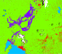
1. The image of 15 January is very cloudy. Why has it been considered for this exercise despite that? What can you see in this image that you cannot see in the image of 31 January?
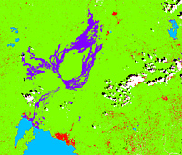
| | Supervised classification of 31 January 2003 Landsat image | |
| | Supervised classification image of 15 January 2003 | |
Look at the ’Monitoring of Volcanic Hot Spots and Plumes’ exercise to see what can be done so that volcanic plumes are not identified as clouds.
|