Earthquakes IntroductionIzmit earthquakeFloods Thessaloniki (Greece)Hurricanes Storm surgesHurricane KatrinaVolcanoes IntroductionAndean Volcanic BeltEtnaNyiragongo and Nyamuragira
|  | | | | | | | | Nyiragongo volcano | |
Nyiragongo and Nyamuragira
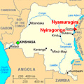
The Nyiragongo volcano (1°31'20"S, 29°15'00"E) is situated in the Democratic Republic of Congo in Central Africa. With its height of 3470 m, it is one of Africa’s most significant volcanoes, and has a typical strato formation with steep slopes.
| | | Major volcanoes in the Democratic Republic of the Congo |
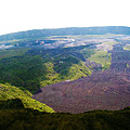
Before draining catastrophically through its outer flanks in 1977, Nyiragongo contained a 1.2 km-wide lava lake in its deep summit crater which was active for half a century.
100 parasitic cones are primarily located along radial fissures south of Shaheru, east of the summit, and along a NE-SW zone extending as far as Lake Kivu. The extremely fluid 1977 lava flows caused many fatalities, as did lava flows that inundated portions of the major city of Goma from 17 January to 3 February 2002. Further significant eruptions took place from June to October 1982, and again between 1994 and 1996. At present the volcano is active and erupts occasionally.
| | Nyamuragira volcano | |
Located to the NW of Nyiragongo is Africa’s most active volcano, Nyamuragira (1°24'30"S, 29°12'0"E). In contrast to the steep-sided Nyiragongo, the Nyamuragira is a massive, broad, and low-angle shield volcano with an elevation of 3058 m rising 25 km north of Lake Kivu across the broad East African Rift Valley.
| | | Map of Virunga National Park |
It has a small 2 km by 2.3 km summit caldera that has walls up to about 100 m high. It had a lava lake in the summit crater, active since at least 1921, which was drained in 1938 at the time of a major flank eruption. Extensive lava flows cover an area of 1500 km2. Eruptions have been recorded as far back as 1550.
Historical lava flows extend down the flanks more than 30 km from the summit, reaching as far as Lake Kivu. A significant eruption occurred between 6 February and approximately 5 April 2001. The last documented eruption took place in 2006.
| |
| | Nyiragongo and Nyamuragira Change detection and hazard assessment Worksheet introductionExercise 1: Exploring and learning about the volcanoExercise 2: Lava Detection using Supervised ClassificationExercise 3: Multitemporal Change Detection and MonitoringEduspace - Download Nyiragongo_Landsat.zipEduspace - Software LEOWorks 3LEOWorks 3 Tutorial
|