Sobre o Eduspace O que é o Eduspace?Que ferramentas oferece? Escolha o seu idioma… Princípios de Detecção Remota O que é a detecção remota?Detecção remota em profundidadeHistória da observação da TerraCartografia e dados de satéliteÓrbitas dos satélitesSatélites de Observação da Terra Recursos… Multimédia Earth images galleryGaleria de ImagensGaleria de VídeoServiços Contact usPesquisa em Eduspace
|  | | | | | | | Article Images |  |
Objectos observados
| Meteorological satellite network: as at March 2002 the WMO community can rely on data from four polar orbiting and five geostationary satellites. Image: WMO
Credits: WMO | |  |  | |
| | | | | On the upper left image, the satellite is placed on an orbit relatively far from the Earth (± 36 000 km). This is why it is
possible to see the "whole" planet.
Credits: ESA | | | | |
| | | | | On this figure, the satellite orbit is much closer to the Earth (± 800 km). Each square (black and red) represents one image. When several images are joined to each other to form a bigger image, scientists talk about a 'mosaic' being created.
Credits: ESA | | | | |
| | | | | West London TM image.
Credits: Window on the UK 2000 | | | | |
| | | | | West London aerial map.
Credits: Window on the UK 2000 | | | | |
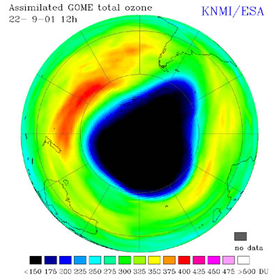
| | | | | Ozone hole over the South Pole during September 2001 taken by GOME. Image: KNMI, The Netherlands
Credits: KNMI, The Netherlands | | | | |
| |
| | Elementos de detecção remota As plataformasOs sensoresAs informações contidas numa imagem
|