
|
Manual exercises
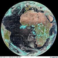
The weather images of Europe and Africa are mostly taken by the European satellite Meteosat. This satellite is located at a geostationary orbit over the equator, at 0° latitude and an altitude of 36 000 km, where it transmits images in different spectral bands. These images are especially suitable for the diagnosis and analysis of weather conditions. Images of geostationary weather satellites show the overall weather situation around the world. The infrared images also provide information on the temperatures of the earth and cloud surfaces. Every temperature range is shown in a certain greyscale. This scale ranges from black to white. Black represents regions of hot temperatures like the Sahara desert in Africa. Clouds for example appear from a dark grey to white, depending on their altitudes and thus their surface temperatures.
Print the image and classify the cloud structures using the explanation above.
Last update: 17 April 2013
| ||||||||||||||||||||||||||||||||||||||||||||||||||||||||||||||||||||