Germany
 Austria
 Belgium
 Denmark
 Spain
Spain
 Estonia
 Finland
 France
 Greece
 Hungary
 Ireland
 Italy
Italy
 Luxembourg
 Norway
 The Netherlands
 Poland
 Portugal
 Czechia
 Romania
 United Kingdom
 Slovenia
 Sweden
 Switzerland


Cryptic Mars, a land shaped by ice
ESA’s Mars Express has captured an astonishing array of landforms emerging from a thick winter blanket of frost as spring arrives in the south polar region of Mars. Some of these features are surprisingly dark compared with their icy surroundings, earning their nickname of ‘cryptic terrain’.

The seasonal polar caps of Mars are mainly composed of carbon dioxide ice with some water ice. The ice partially sublimates (turns directly from solid ice into vapour) in spring, releasing large amounts of gas into Mars’ thin atmosphere. In autumn, the vapour condenses again, and the polar caps grow. By late winter they may even reach as far as 55 degrees latitude – roughly the equivalent of Scotland and Denmark’s southern reaches if translated to the northern hemisphere of Earth.
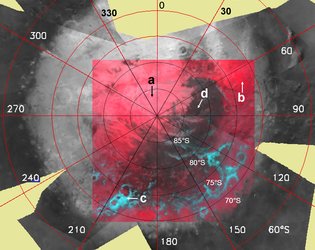
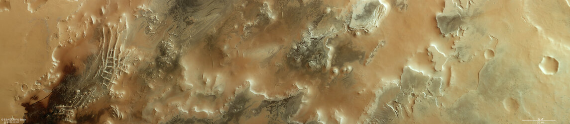
This freeze-thaw cycle gives rise to a variety of curious surface features, many of which are captured in these images of the Australe Scopuli region close to the south pole of Mars. The images were taken by the High Resolution Stereo Camera (HRSC) onboard Mars Express on 2 April 2024 during southern hemisphere spring.
Story continues below gallery


The left side of the main image is dominated by a thick stack of exposed layered deposits, formed as layers of ice freeze with varying amounts of dust trapped within. The right side of the main image shows the smooth surface of these polar layered deposits.
Dark-toned terrain dominates the centre of the scene. Originally nicknamed cryptic terrain because it was unclear why these emerging features are much darker than the rest of the ice cap, researchers now have a better idea as to the processes at play in this dynamic region.
Periglacial patterns
Zooming into the dark region in the main image reveals that the surface is covered with a pattern of polygon shapes at a range of scales. Each polygon is bounded by troughs or ridges, and sometimes the troughs trap bright frost.

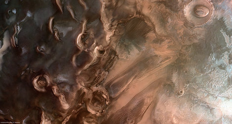
For a closer look at polygonal terrain we can turn to higher resolution imagery provided by ESA’s Trace Gas Orbiter. Although the example shown here (above) is from a different area in Mars’ southern latitudes, it beautifully illustrates the occurrence of lingering ice at the polygon edges in and around an impact crater, on a cold springtime morning.
On Earth, this pattern is a common periglacial feature in arctic and antarctic regions that usually indicates the presence of water ice in the ground. ‘Periglacial’ refers to regions and processes where cold climate contributes to the evolution of landforms and landscapes. The polygons form from freeze-thaw cycles of ground ice over the course of several years, or even centuries. Studying these kinds of patterns on Mars can help researchers decipher the climate history of the planet.

Jets and fans
In many locations throughout the image, bright and dark fan-shaped deposits can be seen. They range from tens of metres to several hundreds of metres and are oriented in the direction of prevailing winds.
When sunlight penetrates through the translucent carbon dioxide ice layer in early spring it warms up the underlying surface. The ice at the bottom of the layer begins to sublimate, creating pockets of trapped gas. The pressure builds up and the overlying ice suddenly cracks. Jets of gas burst through the surface, carrying dark dust from below. The dust falls back to the surface in a pattern shaped by the direction of the prevailing wind.
The process is similar to that which creates the ‘spider’ features presented in another recent Mars Express image release.

After the dark material has settled on top of the ice, a second phase kicks in as the ice and new layer of dust interact.
The dark material absorbs more sunlight than the brighter, reflective ice and so it warms up the ice it fell on top of and the dark grains gradually sink through the ice. At the same time, this accelerates the process of sublimation, creating a hole. Either fresh ice is revealed underneath, or new frost may then condense on top of the sinking dark grains, resulting in a bright fan at the place of the initially dark fan.
This process is only observed in spring. Once the seasonal translucent ice layer has completely sublimated, the fans become indistinguishable from the underlying surface.

Exploring Mars
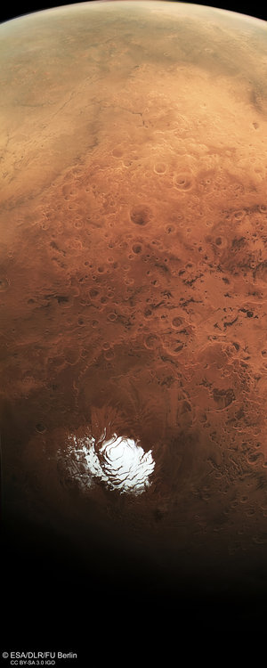
It is thanks to the longevity of missions like Mars Express, which arrived in orbit around the Red Planet in 2003, that seasonal changes can be observed over many years and once-cryptic features can be better understood.
As well as studying the ice caps of the planet the HRSC has shown us the full range of Mars’ geological features, from wind-sculpted ridges and grooves to sinkholes on the flanks of colossal volcanoes to impact craters, tectonic faults, river channels and ancient lava pools.
With its suite of eight instruments Mars Express also maps the planet’s minerals, explores the composition and circulation of its atmosphere, probes beneath its crust, and studies the martian environment.
The mission has been immensely productive over its lifetime, creating a far fuller and more accurate understanding of our planetary neighbour than ever before.
The Mars Express High Resolution Stereo Camera (HRSC) was developed and is operated by the German Aerospace Center (Deutsches Zentrum für Luft- und Raumfahrt; DLR).