


 Germany
 Austria
 Belgium
 Denmark
 Spain
Spain
 Estonia
 Finland
 France
 Greece
 Hungary
 Ireland
 Italy
Italy
 Luxembourg
 Norway
 The Netherlands
 Poland
 Portugal
 Czechia
 Romania
 United Kingdom
 Slovenia
 Sweden
 Switzerland


Deep fractures and water-carved valleys
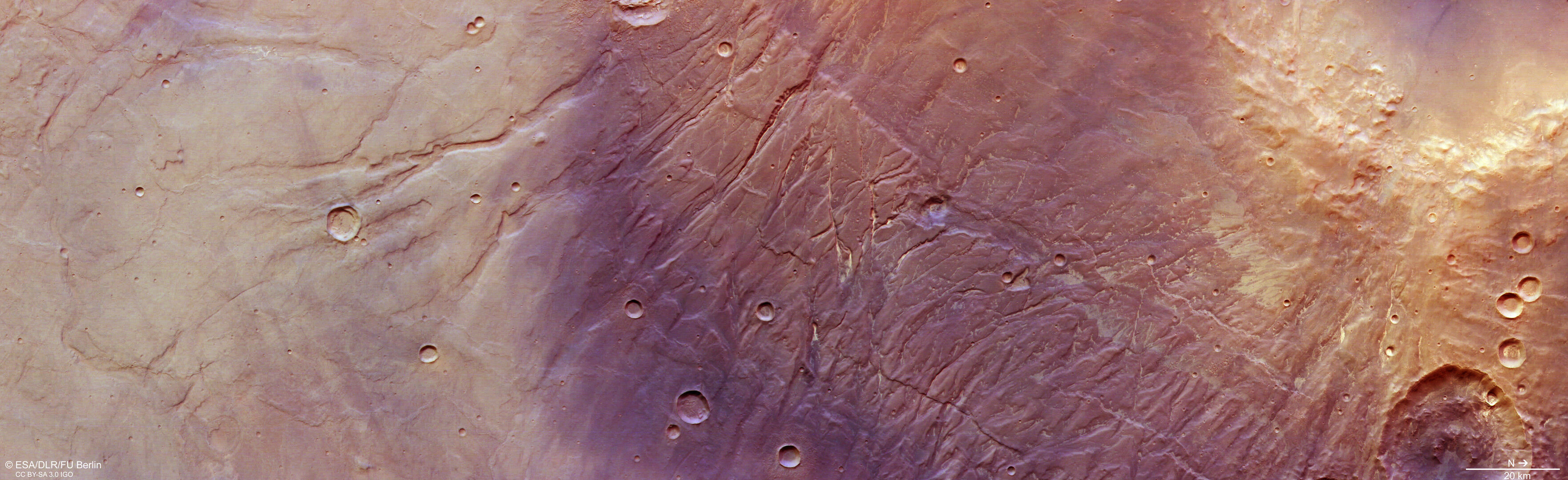
Mars displays fascinating geology everywhere you look – and nowhere is this more true than in the fractured, wrinkled ground seen in this image from ESA’s Mars Express.
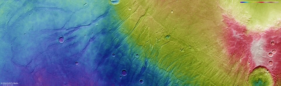
The scene, captured by the High Resolution Stereo Camera (HRSC) on the Mars Express orbiter, features the flanks of a vast volcanic plateau named Thaumasia Planum. The highest features visible here are a whopping 4500 m taller than the lowest, as seen most clearly in the associated topographical map. Many thought to have changed very little since they formed nearly four billion years ago, giving an exciting glimpse into Mars’ earliest days.
Shifting plates

This complex region appears to have been shaped by both tectonics (deformation of the planetary crust) and by past running water.
While Mars no longer displays signs of active tectonics, this has not always been the case.
Mars’ crust once experienced significant stresses in this region, creating the deep surface fractures today known as Nectaris Fossae. These are visible as near-vertical scars at the centre of this image and have since been filled by light-coloured dust. They are thought to have formed in relation to the colossal Valles Marineris canyon system, the largest such system not only on Mars but in the Solar System. Valles Marineris lies just to the north (right) of this region.
Flowing water
After tectonism reworked this patch of Mars, water flowed across the surface, cutting into the rock and carving out deep valleys as it did so (features named Protva Valles – the plural ‘Valles’ referring to multiple channels). These channels can be seen spread across these images; some are broad and superficial and some far deeper. The dense patch of water-carved valleys to the bottom right of the image is intensely eroded.

Protva Valles formed when water was far more plentiful across the surface of Mars, some 3.8 billion years ago, and has remained largely unchanged since.
Built on lava

The underlying terrain here – Thaumasia Planum – formed in the very earliest days of Mars and is largely made up of immense lava flows several kilometres thick.
This time was a turbulent one, with many of Mars’ standout features just beginning to form. The Tharsis volcanoes, some of the largest in the Solar System, are located near to Thaumasia Planum; the load and stress of these volcanoes forming may have prompted this region to begin fracturing, before these volcanoes then flooded the area with lava.

As these lava flows cooled and solidified on unstable, shifting ground, they became compressed, resulting in ‘wrinkle ridges’. One of the most substantial ridges is seen to the bottom-right of centre as an unsteady diagonal line scored into the surface.
Following this extensive resurfacing by lava, Thaumasia Planum was covered in volcanic ash and dust, before the water flows cut through the lava to form the Protva Valles. The origin of these water flows remains unclear; they appear to emerge at different heights, implying that water may have seeped through subsurface layers of Mars.
Exploring Mars
Mars Express has been orbiting the Red Planet since 2003, imaging the surface of Mars, mapping its minerals, identifying the composition and circulation of its tenuous atmosphere, probing beneath its crust, and exploring how various phenomena interact in the martian environment.
The mission’s High Resolution Stereo Camera (HRSC) was developed and is operated by the German Aerospace Center (Deutsches Zentrum für Luft- und Raumfahrt; DLR).
