Germany
 Austria
 Belgium
 Denmark
 Spain
Spain
 Estonia
 Finland
 France
 Greece
 Hungary
 Ireland
 Italy
Italy
 Luxembourg
 Norway
 The Netherlands
 Poland
 Portugal
 Czechia
 Romania
 United Kingdom
 Slovenia
 Sweden
 Switzerland


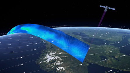
UK-built spacecraft uses lasers to illuminate the winds
A UK-assembled satellite that uses pioneering laser technology to monitor the winds sweeping across the planet has far outstripped the original objective of its mission.
Launched into a low-altitude orbit from Europe’s Spaceport in French Guiana in August 2018, the mission – called Aeolus – has already exceeded its expected lifespan of three years.
The mission set out to help address the need for global wind measurements to facilitate improved weather forecasts and advance understanding of the atmosphere.
It was originally developed as a research and demonstration satellite but, thanks to the high-quality information it delivers, Aeolus has gone way beyond its initial goals.

One of the mission’s biggest accomplishments was achieved in January 2020 when the European Centre for Medium Range Weather Forecasts (ECMWF) started to assimilate Aeolus data into its weather prediction models.
ECMWF was soon followed by other major meteorological centres, including the US National Oceanic and Atmospheric Administration and the British Met Office, further demonstrating the accuracy of the mission’s observations.
In addition, the strong success of the mission has paved the way for future wind-monitoring satellites.
Aeolus – built by Airbus Space and Defence in the UK – probes the winds using a sensor called Aladin.
The instrument fires short pulses of ultraviolet light towards the planet which bounce off air molecules and other particles as they are blown through the atmosphere. The tiny fraction of light that scatters back towards the satellite is collected by a large telescope. By measuring the change in frequency of this backscatter, Aeolus can determine the speed and direction of the wind in the lowermost 30 km of the atmosphere.
As well as informing improved weather forecasts, Aeolus data is being used for numerous other applications, including monitoring Saharan dust and volcanic eruption plumes, improving understanding of polar stratospheric clouds, measuring atmospheric gravitational waves, and much more.
In addition, remote sensing experts from around the world are using Aeolus data to test-out many new applications, thanks to the accessibility of the mission’s data.
The continued success of Aeolus was explored at the mission’s third anniversary conference, which took place in the coastal town of Taormina on the Italian island of Sicily from 28 March to 1 April.
Aeolus is part of ESA’s Earth Explorers programme, a series of missions that explore the complex interactions between the planet’s systems.