About ESA
The European Space Agency (ESA) is Europe’s gateway to space. Its mission is to shape the development of Europe’s space capability and ensure that investment in space continues to deliver benefits to the citizens of Europe and the world.
Highlights


Latest


Space in Member States
Find out more about space activities in our 23 Member States, and understand how ESA works together with their national agencies, institutions and organisations.
 Germany
 Austria
 Belgium
 Denmark
 Spain
Spain
 Estonia
 Finland
 France
 Greece
 Hungary
 Ireland
 Italy
Italy
 Luxembourg
 Norway
 The Netherlands
 Poland
 Portugal
 Czechia
 Romania
 United Kingdom
 Slovenia
 Sweden
 Switzerland
Science & Exploration
Exploring our Solar System and unlocking the secrets of the Universe
Go to topicAstronauts


Latest


Enabling & Support
Making space accessible and developing the technologies for the future
Go to topicLatest


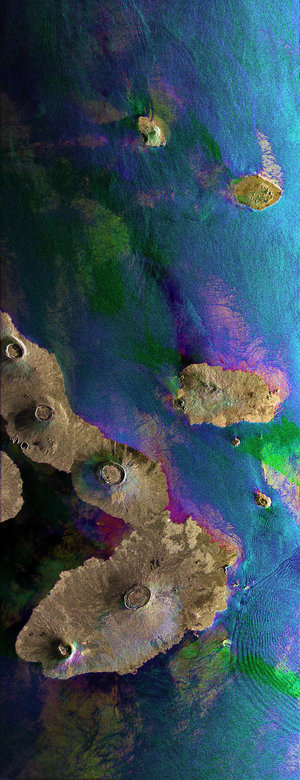
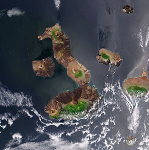
Galapagos Islands in the Pacific Ocean
This Envisat image features the Galapagos Islands, an archipelago situated some 1000 km to the west of Ecuador in the Pacific Ocean. Galapagos’s largest island is Isabela (visible). The five volcanoes seen on the island are (from north to south): Wolf Volcano, Darwin Volcano, Alcedo Volcano, Sierra Negra Volcano and Cerro Azul Volcano. The bigger island to the right of Isabela is Santiago Island.
The image was obtained by combining three Advanced Synthetic Aperture Radar (ASAR) acquisitions (23 March 2006, 14 August 2008 and 1 January 2009) taken over the same area. The colours in the image result from variations in the surface that occurred between acquisitions. Apart from mapping changes on the land surface, radar data can also be used to determine sea surface parameters like wind speed, wind direction and wave height. Different wave types and wind speeds are visible in the image as ripples on the water surface.