Germany
 Austria
 Belgium
 Denmark
 Spain
Spain
 Estonia
 Finland
 France
 Greece
 Hungary
 Ireland
 Italy
Italy
 Luxembourg
 Norway
 The Netherlands
 Poland
 Portugal
 Czechia
 Romania
 United Kingdom
 Slovenia
 Sweden
 Switzerland


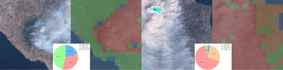
AI for wildfire detection
The PhiFireAI app demonstrates how onboard AI processing can detect wildfires autonomously.
Using images acquired by the Φsat-2 multispectral camera, the app makes use of machine learning techniques, specifically convolutional neural networks, to autonomously identify areas that are subjected to wildfire, along with areas that are safe, areas that are burnt, and bodies of water.
PhiFireAI inspects the images by checking for key features such as the presence of water, smoke from a wildfire, burnt areas near a wildfire, and safe areas that have none of these characteristics. The features are classified accordingly and then the data can be downlinked for further processing.
The application is specifically aimed at:
- Minimising time spent processing and analysing images by human operators
- Reducing the volume of downlinked images. If no fire or burnt areas are detected no data are returned
- Improving early-warning operations
- Enriching wildfires databases
The application is expected to accurately detect the different areas in each tile, reconstruct the full image, and downlink information when needed.
This information can assist relevant authorities such as firefighters so that they can intervene promptly to avoid further damage to nearby areas. The correct classification of areas of water can be a plus for identifying water sources that could be used to help alleviate the situation.
PhiFireAI is developed by Thales Alenia Space in Italy.
The app was a winner in ESA’s OrbitalAI Challenge.