About ESA
The European Space Agency (ESA) is Europe’s gateway to space. Its mission is to shape the development of Europe’s space capability and ensure that investment in space continues to deliver benefits to the citizens of Europe and the world.
Highlights


Latest


Space in Member States
Find out more about space activities in our 23 Member States, and understand how ESA works together with their national agencies, institutions and organisations.
 Germany
 Austria
 Belgium
 Denmark
 Spain
Spain
 Estonia
 Finland
 France
 Greece
 Hungary
 Ireland
 Italy
Italy
 Luxembourg
 Norway
 The Netherlands
 Poland
 Portugal
 Czechia
 Romania
 United Kingdom
 Slovenia
 Sweden
 Switzerland
Science & Exploration
Exploring our Solar System and unlocking the secrets of the Universe
Go to topicAstronauts


Latest


Enabling & Support
Making space accessible and developing the technologies for the future
Go to topicLatest


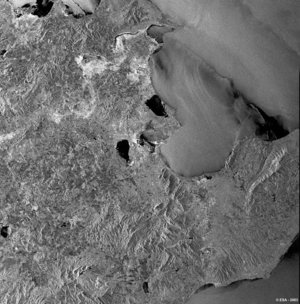
First ASAR - Artemis image, Tanzania 12 March 2003
This ASAR WSM image is the first transmitted via the satellite Artemis. The acquisition, 414 km x 393 km (range x azimuth), shows an area centred over the southwest of Tanzania. In the bottom half section of the image, parts of lakes are clearly visible. Lakes Rukwa (left) and Malawi (bottom) lie in the Great Rift Valley, a tremendous geological fault system extending from the Middle East to Mozambique, crossing Tanzania from the northeast to the southwest. The Ruaha National Park, located on the far north side of the Lake Malawi, is one of Tanzania's least accessible parks, remaining almost totally untouched and preserving a unique wildlife.
On the southern side of Ruaha National Park are the Usangu Flats, a vast zone of alluvial wetlands. The variations in the grey tones in the wetlands indicate a change in soil moisture.
As seen over the lakes, water is like a mirror for the radar signal, reflecting away from the antenna the energy backscattered. As a result, wet areas generate dark grey tones within the image.
Technical Information:
Instrument: Advanced Synthetic Aperture Radar (ASAR)
Mode: WSM
Acquisition date: 12 March 2003
Orbit number: 5385Orbit
direction: Descending
Polarisation: VV
Resolution: 150 metres