About ESA
The European Space Agency (ESA) is Europe’s gateway to space. Its mission is to shape the development of Europe’s space capability and ensure that investment in space continues to deliver benefits to the citizens of Europe and the world.
Highlights


Latest


Space in Member States
Find out more about space activities in our 23 Member States, and understand how ESA works together with their national agencies, institutions and organisations.
 Germany
 Austria
 Belgium
 Denmark
 Spain
Spain
 Estonia
 Finland
 France
 Greece
 Hungary
 Ireland
 Italy
Italy
 Luxembourg
 Norway
 The Netherlands
 Poland
 Portugal
 Czechia
 Romania
 United Kingdom
 Slovenia
 Sweden
 Switzerland
Science & Exploration
Exploring our Solar System and unlocking the secrets of the Universe
Go to topicAstronauts


Latest


Enabling & Support
Making space accessible and developing the technologies for the future
Go to topicLatest


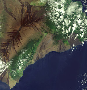
Hawaii, USA - MERIS, 13 December 2002
This Medium Resolution Imaging Spectrometer (MERIS) image shows Hawaii, also known as “Big Island”. This island is part of the state of Hawaii, United States. Due to its origin, the island of Hawaii is subject to frequent earthquake tremors and volcanic activity.
Hawaiian islands have lush tropical forests due to the union of heavy rainfall and fertile volcanic soil. On the eastern side of Hawaii island, the image shows the greater prevalence of vegetation due to moisture brought in by the prevailing Pacific trade winds, while the western side is drier. Light green and yellow areas in the image correspond to human settlements and the leading crops of the island: sugar cane, coffee and pineapples.
The inactive volcano Mauna Kea (4205 meters), the highest peak in the state, can be seen in the north centre of the island. The dark, lava-streaked flanks, covering about 50 per cent of Hawaii, correspond to the active Mauna Loa volcano (4170 meters) that dominates the south of the island. Smoke, visible in the east part of the image, is rising from Kilauea crater – the most active volcano on Earth. A greyish plume of smoke can be seen on the east coast, to the right of Kilauea volcano, due to Kilauea continually spills lava into the Pacific Ocean.
Technical Information:
Instruments: MEdium Resolution Imaging Spectrometer (MERIS)
Date of Acquisition: 13 December 2002
Orbit number: 04119
Orbit Direction: Descending
Instrument features: Full Resolution image (300 - metre resolution)
Band Combination: R = 665 nm, G = 560 nm, B = 442.5 nm (channel = wavelength)