About ESA
The European Space Agency (ESA) is Europe’s gateway to space. Its mission is to shape the development of Europe’s space capability and ensure that investment in space continues to deliver benefits to the citizens of Europe and the world.
Highlights


Latest


Space in Member States
Find out more about space activities in our 23 Member States, and understand how ESA works together with their national agencies, institutions and organisations.
 Germany
 Austria
 Belgium
 Denmark
 Spain
Spain
 Estonia
 Finland
 France
 Greece
 Hungary
 Ireland
 Italy
Italy
 Luxembourg
 Norway
 The Netherlands
 Poland
 Portugal
 Czechia
 Romania
 United Kingdom
 Slovenia
 Sweden
 Switzerland
Science & Exploration
Exploring our Solar System and unlocking the secrets of the Universe
Go to topicAstronauts


Latest


Enabling & Support
Making space accessible and developing the technologies for the future
Go to topicLatest


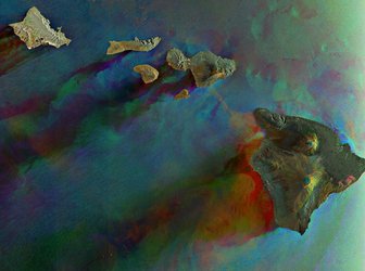
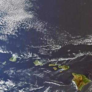
Big Island, Hawaii
The volcanic landscape of the largest island in the Hawaiian archipelago is pictured in this Sentinel-2A satellite image.
Located in the central Pacific Ocean, the islands, atolls and islets of Hawaii developed from a hotspot in Earth’s mantle that leaked magma as the Pacific tectonic plate moved northwest, creating a trail of exposed rock.
The island pictured here is the southeastern-most island – and therefore youngest of the chain – and is volcanically active. We can clearly see the Mauna Loa volcano in the upper left with the darker remnants of lava flows down its gentle slopes. The other active volcano, Kīlauea, can be seen smoking near the centre of the image. Both active volcanos sit within the Hawaii Volcanoes National Park.
Throughout the image, the brown and black lava flows – the darker being younger – are interspersed with green forests and fields. The clouds in this very high-rainfall area are formed by trade winds from the northeast being blocked by the mountains in the middle of the ocean, which also leads to frequent heavy rainfall.
On the centre-right side of the image along the coast, we can see a plume of steam where lava flows into the ocean. The lava is seeping out of a fissure in a nearby lava lake and making its way into the ocean. Nearby, we can also see the discontinuation of a road, cut off by a lava flow.
This image, also featured on the Earth from Space video programme, was captured by the Copernicus Sentinel-2A satellite on 27 October 2016.
The Sentinel-2 mission comprises two satellites. Sentinel-2A has been in orbit since 2015; its twin, Sentinel-2B, is set for launch during the night of 6/7 March. Together, the satellites will revisit the same spot over the equator every five days, and even more often at higher latitudes.