About ESA
The European Space Agency (ESA) is Europe’s gateway to space. Its mission is to shape the development of Europe’s space capability and ensure that investment in space continues to deliver benefits to the citizens of Europe and the world.
Highlights


Latest


Space in Member States
Find out more about space activities in our 23 Member States, and understand how ESA works together with their national agencies, institutions and organisations.
 Germany
 Austria
 Belgium
 Denmark
 Spain
Spain
 Estonia
 Finland
 France
 Greece
 Hungary
 Ireland
 Italy
Italy
 Luxembourg
 Norway
 The Netherlands
 Poland
 Portugal
 Czechia
 Romania
 United Kingdom
 Slovenia
 Sweden
 Switzerland
Science & Exploration
Exploring our Solar System and unlocking the secrets of the Universe
Go to topicAstronauts


Latest


Enabling & Support
Making space accessible and developing the technologies for the future
Go to topicLatest


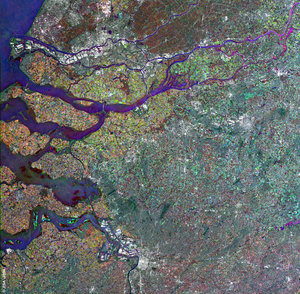
Paris, France - ASAR, 5 July 2003
This Advanced Synthetic Aperture Radar (ASAR) multitemporal colour composite image shows an area of 100 Km swath width centred over Paris, France, shown as a large bright area. The image is made of three ASAR images acquired on different dates and assigning a colour (RGB) to each date (Red: 11 January 2003, Green: 3 July 2003, Blue: 3 April 2003).
Visible landmarks are the Seine River that flows across the image, the Peripherique (City Ring), the Charles De Gaulle (north of Paris) and the Orly International (south) Airports.
The gray-greenish patches just outside the Paris Ring Road are the Bois de Boulogne (west) and the Bois de Vincennes (east). The faint line running from the centre of Paris westward is the line formed by the Louvre, the Tuileries Gardens (along the Seine river), the Champs-Elysees, and the Defense.
The magenta and yellow colours around the city are agricultural fields, mostly the wheatfields of the Beauce region, which show a high degree of change from one season to the next.
Technical Information:
Instrument: Advanced Synthetic Aperture Radar (ASAR)
Dates of Acquisition: 11 January 2003, 26 April 2003, 5 July 2003
Instrument features: Image Mode Precision (30 meter resolution)
ASAR Mode: Image Swath 2
Orbit Direction: Descending
Orbit number: 4528, 6031, 7033
ASAR Polarization: VV
Coordinates:
NW Lat/Long: N 49.24/ E 1.37
NE Lat/Long: N 49.11/ E 3.03
SE Lat/Long: N 48.20/ E 2.45
SW Lat/Long: N 48.33/ E 1.20